This Weekend’s Brutal Cold Snap Isn’t Going Away Anytime Soon


Just stay home. It’s a mantra we’ve lived by for almost a year now (oh good grief), but it’ll take courage to even go check the mail for the next week. The coldest air of the season—the coldest air in the last several seasons—will make itself right at home over the central United States this week, sending low temperatures into the double digits below zero. Wind chills will dip even lower, posing a threat for serious injury if you’re outdoors with exposed skin for any length of time.
After a few frigid days, lows sank like a rock on Sunday morning. Folks from eastern North Dakota to northern Wisconsin woke up to temperatures below -20°F, with the zero-degree line dipping into central Illinois and single digits approaching southern Missouri. That’s pretty darn cold even for regions used to cold winters. Fargo’s average low for February 7th is 2°F. This morning’s low of -21°F is a full 23°F below normal there.
Things are even colder across the border in Canada. Sunday morning’s temperature analysis revealed lows below -40°F in south-central Canada. Saskatoon managed to reach -40°, which is the same misery in both °F and °C.

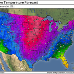
It’s going to remain frigid across the north-central United States through next week. The animation above shows the National Weather Service’s forecast low temperatures from Monday morning (2/8) through Saturday morning (2/13). When you factor in the winds, conditions in the coldest areas will allow frostbite to develop on exposed skin in as little as 15-30 minutes. The wind chill hit -34°F in Minneapolis around 2:00 AM on Sunday.
If current trends hold, towns on the Northern Plains and the Upper Midwest will struggle to climb much above 0°F the entire week. The deepest reserve of Arctic air should remain confined to the central United States. The Rockies will do a good job holding off the cold air for a while, but it’s possible that even Seattle could see lows in the low 20s by the end of the week.
It’s worth pointing out that:
1) the bitter cold could last beyond next weekend and into the following week, and
2) there’s some uncertainty right now about just how far south and east the cold air will slide this week. Don’t be too surprised if forecasts shift over the next few days and that Arctic chill seeps farther than predicted right now.
P***r V****x
Why is it so cold? This is a part of the polar vortex. Yes, that polar vortex.
Any talk of the polar vortex sounds ominous because it’s usually devoid of any meaningful context.
 |
| I intended to use this graphic back on The Vane a few centuries ago but never had the chance, so I recycled it for this Very Instructive And Useful Purpose. |
The term “polar vortex” itself, though it predates us all, seems tailored to our modern attention spans. It’s fodder for overly dramatic nightly news graphics and the perfect hook to tap into some of that sweet, sweet algorithm juice and help posts get around on social media. It’s tough out there right now. I’ve been up against a traffic quota before. I don’t really blame them. (Though it’s annoying, and I totally blame them.)
But the polar vortex isn’t scary. The skies don’t fill with the hum of chanting aliens. The stratosphere doesn’t crash down on Dennis Quaid while he hides in a cargo ship (or a hospital? a mall? I can’t remember, I haven’t watched that movie in forever).
The polar vortex is a large upper-level circulation that sits over the Arctic. This circulation sort of acts like a moat that keeps winter’s coldest air confined to the polar regions. As long as that upper-level circulation remains relatively smooth, conditions will remain stable and the coldest of the cold will stay far to the north.
 |
| Source: TropicalTidbits.com |
It doesn’t take much for a low-pressure system or a ridge of high pressure to destabilize that circulation. This instability results in troughs that swoop over lower latitudes and bring fleeting bursts of cold weather. Some of these troughs can break off and become cutoff lows that linger for days at a time. Frigid Arctic air follows these troughs and cutoff lows to the lower latitudes, which is what they’re talking about when you hear “the polar vortex is coming” ahead of a cold spell.
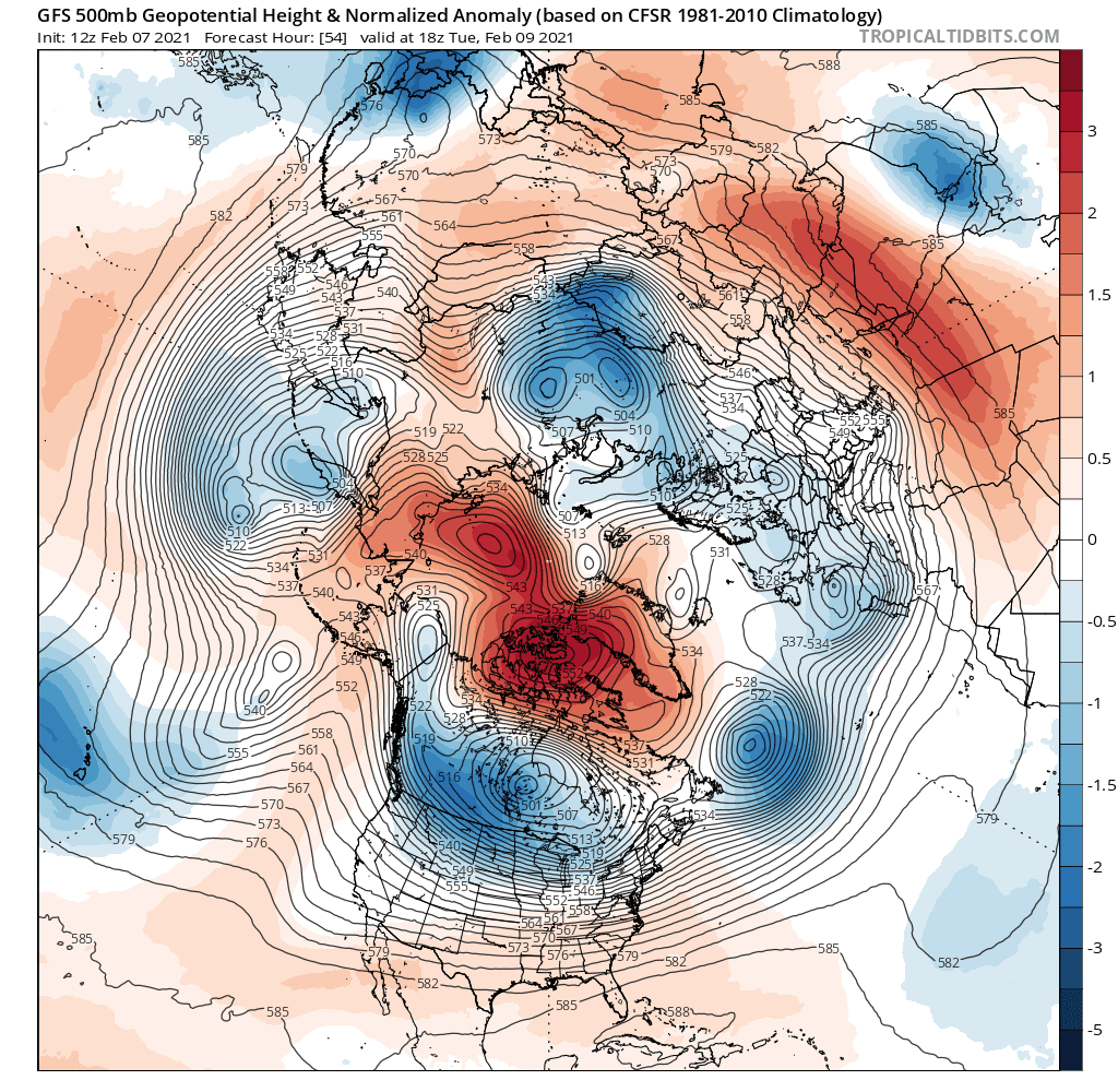
Sometimes, like this week, the entire circulation is displaced by an upper-level ridge over the Arctic, which is what you can see in the model image above. This graphic depicts the height of the 500 millibar layer of the atmosphere on Tuesday.
The dark red over northern Canada shows areas where unusually strong upper-level ridging will bring abnormally warm weather to the Arctic. That ridge displaced the polar vortex circulation and sent it diving south toward us.
 |
| Source: TropicalTidbits.com |
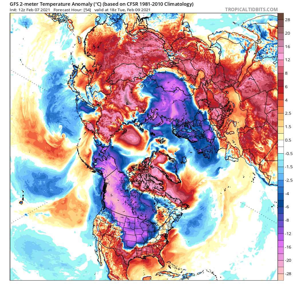
It’s even easier to visualize this displacement when you look at surface temperature anomalies. The model graphic shows temperatures surging above normal in the Arctic while frigid air floods south toward lower latitudes over the United States and Russia.
As long as that anomalous ridge lingers over the Arctic, the cold air will have no choice but to relocate itself, and the United States is in prime location to feel the chill. Bundle up.
You can follow me on Twitter or send me an email.
Please consider subscribing to my Patreon. Your support helps me write engaging, hype-free weather coverage—no fretting over ad revenue, no chasing viral clicks. Just the weather.