Ana Forms Near Bermuda; Hurricane Season Starts Before June For Seventh Year In A Row

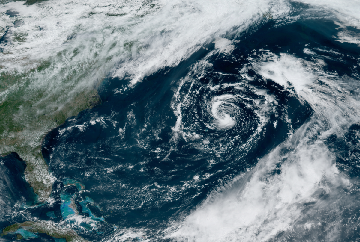
Subtropical Storm Ana formed north of Bermuda on Saturday morning, kicking off the 2021 Atlantic hurricane season more than a week before the season’s “official” start date of June 1—again. This is the seventh Atlantic hurricane season in a row that began early. Ana will remain far out to sea, posing little more than a nuisance to shipping interests and a source for rough seas around Bermuda and parts of the U.S. East Coast.
A low-pressure system meandering in the western Atlantic Ocean took advantage of a brief window where conditions allowed the system to develop into a subtropical storm.
It’s a cute li’l storm on satellite imagery today. The storm has a delightfully swirly appearance and even a clear eye-like feature right at the center of circulation. Ana is conspicuously devoid of much thunderstorm activity, which is common for subtropical storms.

Forecasters expect Subtropical Storm Ana to remain far from land and dissipate in a couple of days. The Bermuda Weather Service dropped their tropical storm watch this morning because the storm’s winds should stay away from the island.
Rip currents are the only effect this storm will have on land. Some beaches in places like North Carolina are on high alert for these fast-moving currents that can pull swimmers out to sea. A rip current forms between waves that hit the beach head-on, forcing this water to drain away from the beach straight out rather than on an angle. Remember, if you’re ever caught in a rip current, don’t panic—rip currents pull you out, not under. Swim parallel to the shore until the current releases you, or tread water and calmly signal for help if possible.
Like most early-season systems, Ana didn’t originate in the tropics and it’s not a fully tropical cyclone. “Cyclone” is the catch-all term for any low-pressure system, regardless of strength or location. A subtropical cyclone is a low-pressure system that has some characteristics of both a tropical cyclone and an extratropical cyclone, or the common type of low-pressure system that brings us most of our active weather.
Subtropical storms aren’t purely tropical because air temperatures aren’t warm all throughout the system and they don’t derive all of their energy from the ocean. Tropical cyclones are powered by thunderstorms around the center of the storm, while subtropical cyclones get at least some of their energy from upper-level winds. Despite their differences, subtropical cyclones are close enough to tropical cyclones in composition and impacts that they warrant full tracking and forecasts from the National Hurricane Center.

This is the seventh hurricane season in a row where we saw the first named storm of the season form before June 1. This trend far surpasses the previous streak of three consecutive early-starting hurricane seasons in 2007, 2008, and 2009. It’s a clear and undeniable trend—probably the mixed result of both a changing climate and better detection methods—and it’s prompted the experts to ponder moving that climatological start date from June 1 to May 15.
The World Meteorological Organization wrote a recommendation a few months ago asking the National Hurricane Center to consider moving the official start of the season in light of all May storms we’ve seen in recent years. The NHC met them halfway for now, beginning their regular tropical forecasts on May 15 while continuing to call June 1 the beginning of the season. It’s likely that they’ll consider officially moving the start date in the years to come.
[Satellite Image: NOAA]
You can follow me on Twitter or send me an email.
Please consider subscribing to my Patreon. Your support helps me write engaging, hype-free weather coverage—no fretting over ad revenue, no chasing viral clicks. Just the weather.