Flooding Rain, Tornadoes Likely As Tropical Storm Elsa Heads Toward Florida


Tropical Storm Elsa is on track to make landfall along Florida’s west coast on Wednesday morning. The storm will bring strong winds and flooding rains to communities in its path, as well as the risk for a storm surge along the coast as it nears landfall. Much of the Florida Peninsula will also see a risk for tornadoes as Elsa passes through the region.
Elsa’s Track

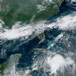
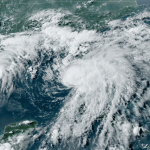
The National Hurricane Center‘s 5:00 PM advisory found that Tropical Storm Elsa had 50 MPH winds as it moves over Cuba southeast of Havana. The storm is heading northwest at 14 MPH as it rounds a ridge of high pressure over the western Atlantic.
Funny enough, even though it’s over land, the storm looks better on satellite now than it has in a few days. Elsa seems to be trying to consolidate itself somewhat as it pushes over Cuba. Satellite imagery reveals that thunderstorm activity appears to be tightening up around the center of the storm, which could help it maintain strength and recover faster once it emerges in the Gulf overnight Monday into Tuesday.
Forecasters expect Elsa to regain a little bit of strength as it approaches landfall in Florida’s Big Bend on Wednesday morning, but moderate southwesterly wind shear could limit how quickly it intensifies. There’s an outside chance it’ll regain hurricane strength before making landfall, but please remember there’s little practical difference between a strong tropical storm and a minimal hurricane.
Elsa will gradually pick up speed after entering the Gulf of Mexico on Monday night. The storm will then start curving northeast as it approaches Florida’s west coast on Tuesday and Wednesday. Elsa will move over coastal portions of Georgia and South Carolina after crossing Florida, eventually falling apart in the northwestern Atlantic by the end of the week.
There’s a chance that the storm could track closer to the East Coast than what’s currently predicted, a scenario firmly within Elsa’s cone of uncertainty. If this happened, heavy rain and gusty winds are possible closer to the I-95 corridor later this week.
The Rain

The potential for flash flooding from heavy rain is, as usual, the most widespread threat associated with Tropical Storm Elsa as it makes landfall in Florida and scoots up the southeast coast.
The Weather Prediction Center expects several inches of rain to fall through midweek, with the greatest totals expected along and to the right of Elsa’s track. The heavy rain will pose a risk for flash flooding from the southern tip of Florida northward to around Myrtle Beach, South Carolina.
Elsa is moving at a steady clip and its speed will increase as it rounds the ridge over the western Atlantic. This forward march will limit the amount of time any one downpour can sit and drench a community. However, tropical systems produce high rainfall rates, and it won’t take long for a downpour to lead to localized flooding issues.
The Storm Surge

A storm surge is possible along Florida’s west coast as Elsa approaches the area on Tuesday and Wednesday. A maximum storm surge of 3-5 feet is possible along coastal communities from Tampa Bay north through the Big Bend if the storm surge coincides with high tide.
The potential for a five-foot storm surge isn’t anything to sneeze at. It’ll be lower for most communities, but any inland push of seawater is dangerous for homes and businesses close to beaches and coastal waterways.
The Tornadoes

Tornadoes are possible on Tuesday across most of the Florida peninsula as Tropical Storm Elsa’s wind and rain begin to overspread the state.
Tropical tornadoes are an ever-present hazard with landfalling storms. Thunderstorms in the outer bands can turn into miniature supercells by tapping into the storm’s own wind shear. Tropical tornadoes usually happen quickly, which can reduce the warning lead time. Make sure you have a way to receive tornado warnings the moment they’re issued, and have a plan to take cover if you go under a warning.
The Wind
Strong winds of 60+ MPH will be a problem for towns near the center of the storm. The winds and gusts of a strong tropical storm can easily knock down trees and toss around loose objects outside. Power outages are likely in some areas.
Remain mindful of trees and limbs that loom near your home, and stay away from those rooms during the high winds. A significant number of non-water injuries and deaths during landfalling storms are the result of trees and tree limbs falling through walls and roofs.
You can follow me on Twitter or send me an email.
Please consider subscribing to my Patreon. Your support helps me write engaging, hype-free weather coverage—no fretting over ad revenue, no chasing viral clicks. Just the weather.