Hurricane Ida On Track To Hit Louisiana As A Powerful Hurricane On Sunday


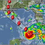
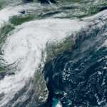
Hurricane Ida is still on track to hit Louisiana as a powerful hurricane on Sunday. The storm is rapidly intensifying in the Gulf of Mexico tonight. The storm has a small eye surrounded by deep convection, a scary look on satellite imagery that often precedes a jump in the storm’s strength.
The forecast hasn’t changed much today. Hurricane warnings remain in effect for all of southeastern Louisiana as Ida charges a path toward the coastline.
New Orleans is in a very bad spot right now. Any jog to the east in the storm’s track will make conditions much worse there.
As I said yesterday, “New Orleans in the eastern eyewall of a major hurricane” is nightmare fuel for meteorologists because of the potential for storm surge and wind damage. (I wrote a post for The Weather Network tonight discussing why Louisiana is so vulnerable to hurricanes.)
The forecasters at NWS New Orleans didn’t pull their punches when they wrote tonight’s forecast discussion.
Once sustained tropical storm force winds move in first responders will button down and YOU WILL BE ON YOUR OWN. Please understand this, there is the possibility that conditions could be unlivable along the coast for some time and areas around New Orleans and Baton Rouge could be without power for weeks. We have all seen the destruction and pain caused by Harvey, Michael, and Laura. Anticipate devastation on this level and if it doesn’t happen then we should all count our blessings.
The details remain the same as the last couple of days.
Ida will push a tremendous storm surge into portions of southwestern Louisiana, which could top 10 feet in some spots. A dangerous and life-threatening storm surge is possible as far east as the Alabama/Florida border, including Mobile Bay.

Torrential rains in Louisiana will lead to widespread flash flood emergencies. The storm surge and intense winds will hamper rescue efforts. Heavy, flooding rains will fall along Ida’s path through the Mid-South and the Mid-Atlantic states. 3-5 inches of rain is a sure bet north through Kentucky, with a couple of inches of rain possible as far east as Washington, Philadelphia, and New York.
Intense wind damage is likely where Ida makes landfall. The NHC keeps using the phrase “potentially catastrophic wind damage” to describe the threat, which is no small thing coming from a very cautious and reserved group of experts. The hurricane’s large and growing wind field will extend far to the west and the east of the point of landfall.

Damaging winds are likely well inland, which is why tropical storm warnings stretch deep into central Mississippi. The widespread and potentially long-lasting power outages far inland from the point of landfall will catch many folks by surprise.
A threat for tornadoes will follow the hurricane inland. The greatest threat exists to the east of the storm, covering parts of Louisiana, Mississippi, Alabama, and Florida’s Panhandle. Tropical tornadoes happen fast, often reducing lead time. Make sure your phone’s wireless emergency alerts are activated and ready to receive tornado warnings.
Hospitals in the south are already overwhelmed by the surge in COVID patients. This hurricane will further strain medical resources and make it harder to treat people who are seriously injured by the storm. The hurricane’s flooding and power outages may cause patients on life support to die. (This has happened before during big disasters.)
The storm and response are basically locked in at this point. If you’re inland—say, around Jackson, Mississippi—you still have Sunday morning to prepare for power outages and wind damage. Otherwise, it’s too close, we’re in too deep, and all that’s left is to watch and hope it weakens.
You can follow me on Twitter or send me an email.
Please consider subscribing to my Patreon. Your support helps me write engaging, hype-free weather coverage—no fretting over ad revenue, no chasing viral clicks. Just the weather.