Ida Will Bring Strong Winds, Flooding Rain Far Inland Over The Next Few Days


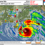
Hurricane Ida made landfall in southeastern Louisiana on Sunday afternoon with maximum sustained winds of 150 mph, making this one of the most intense hurricanes to ever hit the United States. The system took its time winding down over southeastern Louisiana. Ida will weaken as it moves inland, but widespread power outages and flooding rains are likely over the next few days.
Ida joins a most unwanted list of hurricanes that rapidly intensified all the way up to landfall, a once-rare pattern that we’ve seen with many powerful storms—Harvey, Michael, Laura, Zeta, Sally—over the past couple of years.
The hurricane made landfall twice, first in Port Fourchon—a major oil and gas hub in the region—with 150 mph winds, then again a few hours later near Galliano with winds of 145 mph.
NWS New Orleans received a fairly reliable report from Port Fourchon of sustained winds of 149 mph with a gust to 172 mph during Ida’s landfall:
Here is the observation we received. pic.twitter.com/rJiCpJ9Kmg
— NWS New Orleans (@NWSNewOrleans) August 30, 2021
Hurricane Ida took its sweet time winding down due to the brown ocean effect, the tendency for warm, moist soils to mimic warm ocean temperatures that fuel a hurricane.
Calling Louisiana’s wetlands “land” is a bit of an oversell. It’s basically the ocean on a good day, and that’s before a high-end category four hurricane covered the region in hot storm surge. As a result, Hurricane Ida remained a major hurricane for nearly 10 hours after landfall. The satellite image above showed the storm with a fully clear eye about four hours after landfall.
It’s going to be a while before we get a full picture of just what happened in southeastern Louisiana. Early indications are that “not good” is a solid description of events tonight.
New Orleans is entirely without power after the transmission lines that feed the city fell during the hurricane’s high winds. There are reports of significant flooding in some communities nearby from a combination of torrential rains and storm surge.

The system is over solid land now and it’s winding down fast. The National Hurricane Center said in its 11:00 p.m. advisory that the storm was now a category two with 105 mph winds. It should be a tropical storm by Monday morning, a depression by Monday night, and “remnants of Ida” by this time on Tuesday.
Even though the system is weakening, it’s still a very strong hurricane. Damaging winds will extend far inland. The intensity of the tree damage and power outages may shock people as far inland as Jackson, Mississippi.

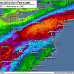
Ida’s torrential rains will lead to a threat for widespread flash flooding over the next few days. Rainfall totals of 3-5″ will be common from Mississippi to Massachusetts and just about everywhere in between. Exact rainfall totals will differ and shift depending on the storm’s ultimate track, but it’s safe to say that Ida’s remnants will bring drenching rains to a large portion of the eastern United States through next week.

A risk for tornadoes will continue on the eastern side of Ida over the next couple of days. The threat is maximized in Louisiana, Mississippi, and Alabama, where small supercells can tap into ample wind shear and produce fast tornadoes.
Tropical tornadoes happen quickly, sometimes reducing tornado warning lead time. Make sure your cell phone’s wireless emergency alerts are activated for tornado warnings so you get a warning right away.
You can follow me on Twitter or send me an email.
Please consider subscribing to my Patreon. Your support helps me write engaging, hype-free weather coverage—no fretting over ad revenue, no chasing viral clicks. Just the weather.