Skip to content
DAMWeather DAMWeather DAMWeather

The weather can get scary. Reporting on it doesn't have to be.

DAMWeather DAMWeather DAMWeather

The weather can get scary. Reporting on it doesn't have to be.

  • About Me
  • All Bylines
    • Books, Bylines, and Press
    • The Skies Above (Book)
    • Extreme Weather (Book)
    • The Weather Network
    • The Vane
    • Forbes
    • Capital Weather Gang
    • Mental Floss
  • Maps
    • Hurricane Maps
    • Hurricane Names
    • Monthly Tornadoes
    • Tornado Tracks
    • F5/EF-5 Tornadoes
    • SPC High Risk Days
  • GIS Resources
  • Contact Me
    • Bluesky
    • Facebook
    • Instagram
  • wxdam.com
  • About Me
  • All Bylines
    • Books, Bylines, and Press
    • The Skies Above (Book)
    • Extreme Weather (Book)
    • The Weather Network
    • The Vane
    • Forbes
    • Capital Weather Gang
    • Mental Floss
  • Maps
    • Hurricane Maps
    • Hurricane Names
    • Monthly Tornadoes
    • Tornado Tracks
    • F5/EF-5 Tornadoes
    • SPC High Risk Days
  • GIS Resources
  • Contact Me
    • Bluesky
    • Facebook
    • Instagram
  • wxdam.com
Close

Search

A Pesky Coastal Storm Will Drench Parts Of The Southeast This Weekend

By Dennis Mersereau
November 6, 2021 2 Min Read
A developing nor’easter will bring dreary conditions to the coastal southeast this weekend, with cool temperatures, pouring rain, and driving winds making things miserable from northern Florida to eastern North Carolina.
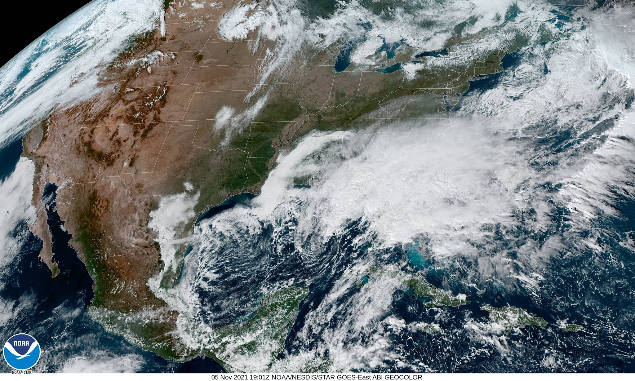
The storm is already in its formative stages over northeastern Florida this evening. It’s not all that impressive on satellite imagery—unless a bland deck of stratus clouds is your thing, then more power to you—but it’s going to slowly grow more organized over the next day or so as it meanders up the coast.
The system and its worst conditions will peak during the day on Saturday, slowly winding down on Sunday as the system pulls away from shore.
This will be a nor’easter that doesn’t affect the northeast. Nor’easters get their name from the northeasterly winds that buffet the coast. There’s going to be plenty of that over the next few days. Winds could gust as high as 40-50 mph in parts of South Carolina and North Carolina.
Strong and persistent onshore winds will lead to widespread coastal flooding from storm surge, especially around high tide. Coastal flood warnings are in effect from Jacksonville, Florida, to southeastern Virginia through the next couple of days.

Heavy rain is going to be a problem near the track of the storm. The bulk of the heavy rain will stay juuust offshore, but a few inches of rain are likely throughout coastal counties from northeastern Florida to eastern N.C.
These totals could inch higher if the storm tracks a little farther west than currently predicted. Any amount of heavy rain is a headache if it falls too quickly, but leaf-clogged gutters and storm sewers will increase the risk for street and parking lot flooding in some areas.

Saturday is going to be a raw and gloomy day for much of the southeast. Northeasterly winds will lead to cold air damming, a phenomenon where cold air pools up at the foot of the Appalachians because it’s too dense to flow up and over the other side. Widespread high temperatures in the 50s are likely as far south as northern Florida. Conditions will warm up a bit on Sunday as the storm moves away.
[Satellite Image: NOAA]


You can follow me on Twitter or send me an email.

Please consider subscribing to my Patreon. Your support helps me write engaging, hype-free weather coverage—no fretting over ad revenue, no chasing viral clicks. Just the weather.
 

Author

Dennis Mersereau

I have 15+ of experience providing hype-free weather information for folks across the United States and around the world. In addition to DAMWeather, I also contribute to The Weather Network as a digital writer and weather specialist.

Follow Me
Other Articles
Previous

Multiple Rounds Of Heavy Rain Heading For The West Coast Through Early Next Week

Next

Season’s First Big Snowstorm Set To Hit Northern U.S. Plains, Canadian Prairies


Local ◈ UTC
Facebook | Bluesky
Instagram | Threads | Email
DAMWeather is now ad-free! Everyone benefits from engaging, hype-free weather coverage. Please consider supporting my efforts through Patreon:


Order The Skies Above today!

Bookshop.org || Barnes & Noble
Mountaineers Books || Amazon

My latest book, The Skies Above, is now available!

Did you know a puffy cloud can weigh millions of pounds? Or that every rainbow you see is unique to you?

Our atmosphere is full of spectacular sights that are always within your reach. Glistening layers of fog, gorgeous sunsets, and brilliant meteors flashing through the sky can light up even the calmest day.

The Skies Above, published by Mountaineers Books, is a celebration of what we overlook when we look up. I was thrilled to work with the editors and illustrators at Indelible Editions to share with you the quotidian beauty of our sky.

Order your copy now and learn about the wonders we take for granted every day.

I teamed up with the editors of Outdoor Life magazine to write The Extreme Weather Survival Manual, your guide to surviving and thriving in almost any weather condition. Whether you're an avid outdoorsperson or you enjoy watching the radar from the comfort of your home, you're sure to find helpful tips, advice, and new bits of knowledge in this fascinating book.

You can buy my book today through Amazon.
  • 2026 (34)
  • 2025 (49)
  • 2024 (59)
  • 2023 (43)
  • 2022 (57)
  • 2021 (71)
  • 2020 (83)
  • 2019 (88)
  • 2018 (92)
  • 2017 (1)
  • 2016 (4)
  • 2015 (10)

Copyright 2026 — DAMWeather. All rights reserved. Blogsy WordPress Theme