More Rounds Of Snow And Ice Will Pelt Parts Of The South Through This Weekend

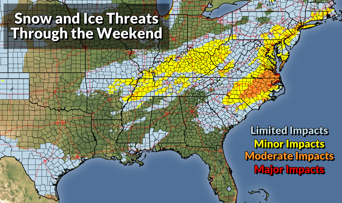
It’s going to be a rough couple of days for folks from the Deep South to the I-95 corridor who can’t stand winter weather. We could see disruptive wintry precipitation across a widespread portion of the southern and eastern states over the next couple of days, culminating with a potentially significant winter storm across the Carolinas heading into the weekend.
The threats cover three main areas:
➤ Snow across the I-95 corridor through the Thursday morning commute
➤ Icing in Texas and parts of the northern Gulf Coast Thursday night into Friday
➤ A significant winter storm in the Carolinas and Virginia Friday into Saturday
Except for the big Carolinas storm, we won’t see big amounts, but it’ll be just enough to snarl travel in each of the affected areas.
Burst of Snow Along I-95 Through Thursday Morning
A cold front moving toward the East Coast will bring some rain to the Mid-Atlantic and Northeast beginning Wednesday night and lasting into Thursday morning. Temperatures will rapidly fall behind the front, allowing much of the precipitation to change over to snow across the I-95 corridor.
We could see this changeover from the D.C. metro area up the interstate into Boston, potentially threatening a very tough morning commute for an area that struggles through a tough morning commute on sunny days.
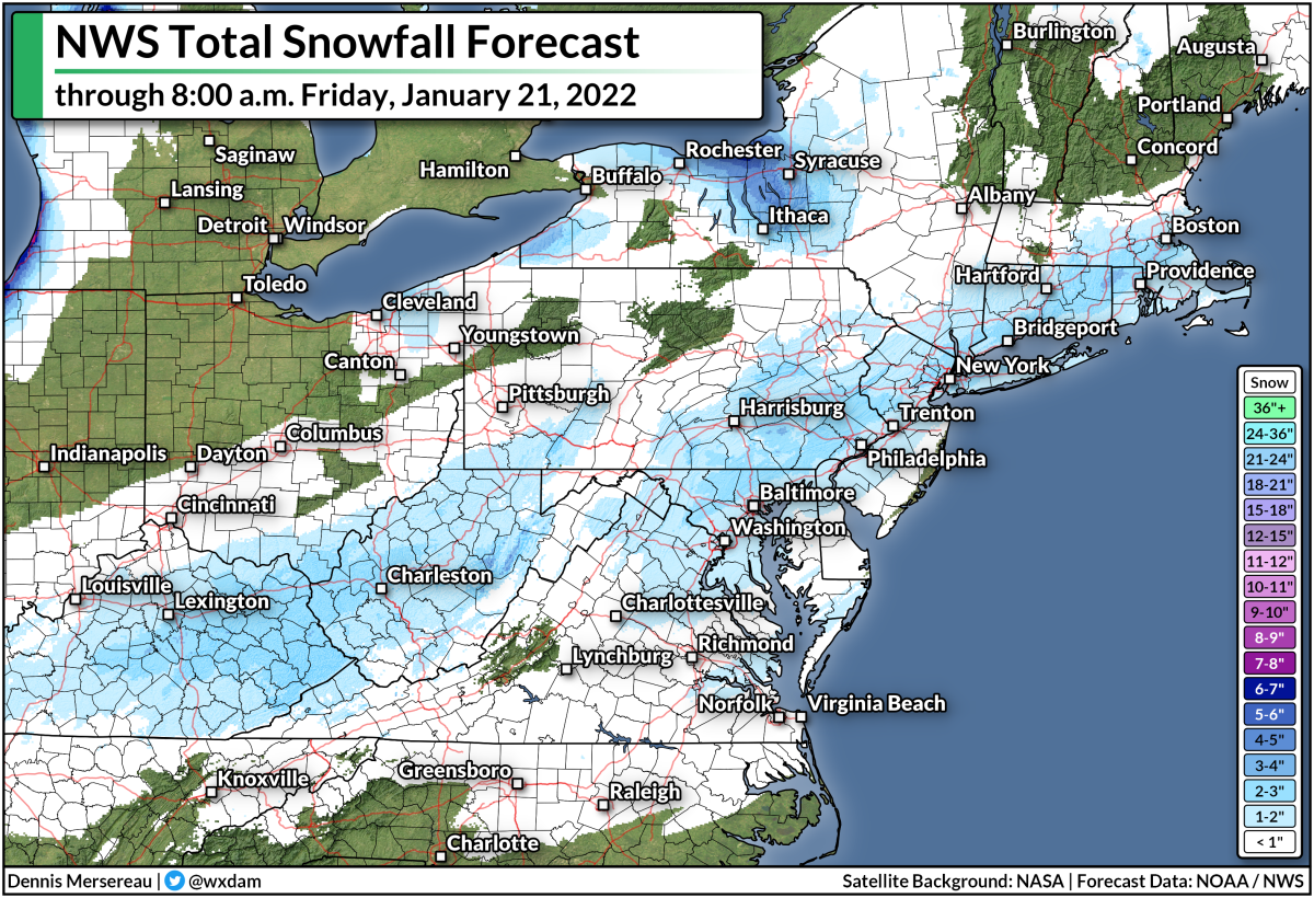
The National Weather Service expects only an inch or two of snow across the region, but that’s plenty to cause serious headaches across the heavily urbanized I-95 corridor.
Light snowfall totals paired with hot traffic can melt the initial snow into a solid sheet of ice on roads, leaving behind a dangerous mess for the remainder of the commute. We’ve seen this plenty of times, especially in the D.C. area.
Deep South Ice Threat Thursday Night Into Friday
Farther south, there’s a threat for freezing rain and even a bit of sleet, especially across parts of southern and central Texas. Winter weather alerts are in effect for a big chunk of Texas that includes San Antonio, Austin, Corpus Christi, and Laredo. The alerts could stretch into the Houston metro area soon.
A cold front slouching through the Deep South on Thursday will leave behind plenty of cold air at the surface. While surface temperatures drop to or below freezing, things will be just a tiny bit warmer aloft, allowing precipitation behind the front to fall as a messy mix of freezing rain and sleet.
 |
| Source: NWS |
The National Weather Service expects a light glaze of ice on Thursday night into Friday morning across a sizeable portion of Texas, with totals pushing one-tenth of an inch in many spots. That’s not enough to cause widespread tree damage or power outages, but it’ll be just enough to make the roads icy, potentially leading to widespread travel issues.
The potential for freezing rain also extends into the northern Gulf Coast, as well, with Baton Rouge, Biloxi, and maybe even Mobile getting in on the chance for a light glaze into Friday morning.
Significant Carolinas Winter Storm On Friday Into Saturday
The smattering of ice and snow will culminate in a significant winter storm across South Carolina, North Carolina, and Virginia beginning on Friday and stretching into the first half of Saturday.
As usual for storms in this part of the country, the northern end of the storm will feature a snow threat while the southern half of the storm is dominated by warmer air and the threat for freezing rain and sleet.
The threat for freezing rain looks particularly concerning across parts of eastern S.C. and N.C., where they can go years between remarkable ice storms. The National Weather Service predicts more than one-quarter of an inch of ice accretion from freezing rain in parts of northeastern S.C. and southeastern N.C., which would lead to widespread tree damage and power outages.
Here’s a look at the NWS’s ice forecast across South Carolina through Saturday morning:

And the agency’s ice accretion outlook for North Carolina over the same period:
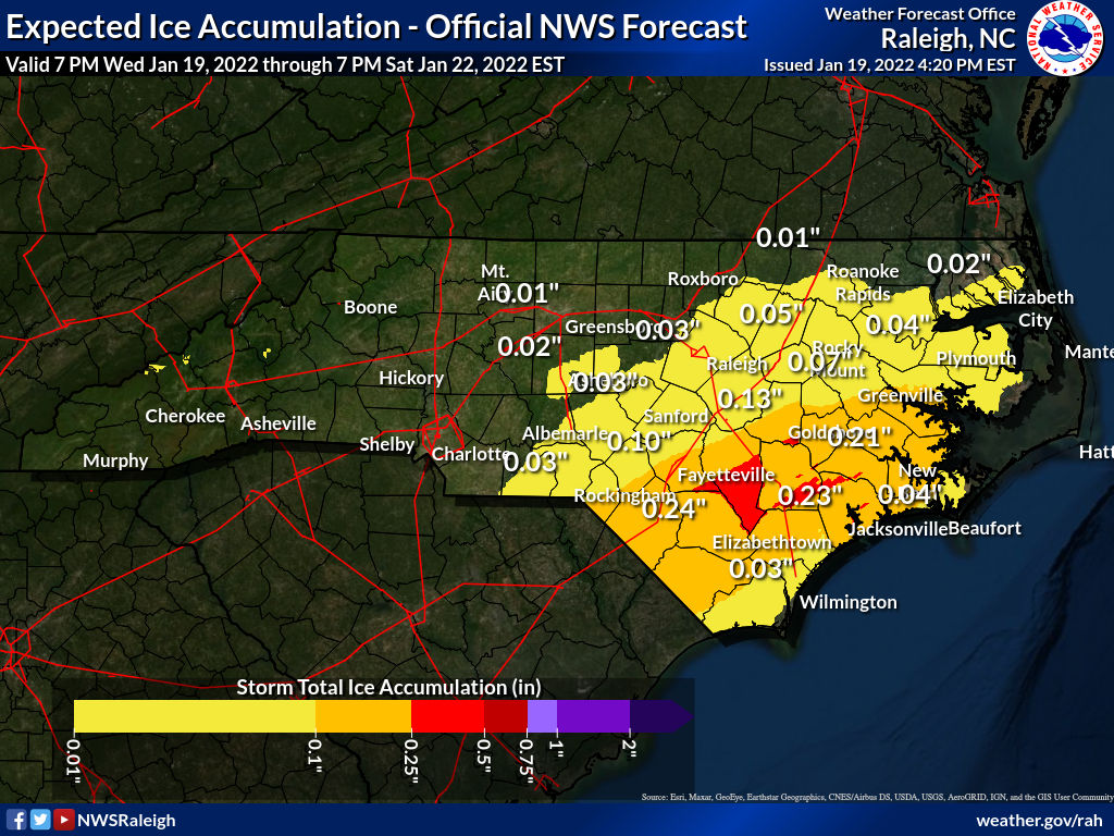
The abrupt changes across county/state lines are due to different NWS offices arriving at different forecasts for their areas of responsibility.
Farther north, snow is in the forecast and some communities could see a decent helping by the end of the storm on Saturday. A bullseye of 6+ inches of snow is possible across northeastern N.C. and parts of the Virginia tidewater, including Norfolk and Virginia Beach.
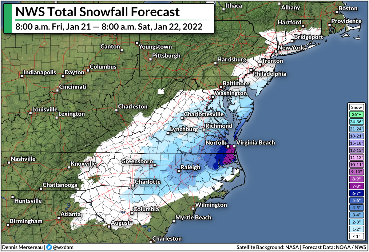
A couple of inches of snow is also possible farther west, especially around the Raleigh-Durham area and even stretching back into the Greensboro and Charlotte metros.
There is some uncertainty surrounding the westward/northward extent of the wintry precip, though, because of dry air potentially disrupting the system and the track of the low possibly stretching farther off the coast.
You can follow me on Twitter or send me an email.
Please consider subscribing to my Patreon. Your support helps me write engaging, hype-free weather coverage—no fretting over ad revenue, no chasing viral clicks. Just the weather.