What You Need To Know About This Dangerous Pre-Christmas Cold Snap & Snowstorm

It’s pouring out of the northern Plains like an avalanche.
The temperature in Wheatland, Wyoming, on Wednesday dropped from 45°F at 9:50 a.m. local time to just 6°F by 10:30 a.m., falling further to -6°F by 12:50 p.m.
This week’s remarkable crush of Arctic air will pick up speed as it hurtles toward the eastern two-thirds of the United States over the next couple of days.
Our cold front will race down the Plains through Thursday, the slug of frigid air curving eastward as a low-pressure system develops over the Midwest.
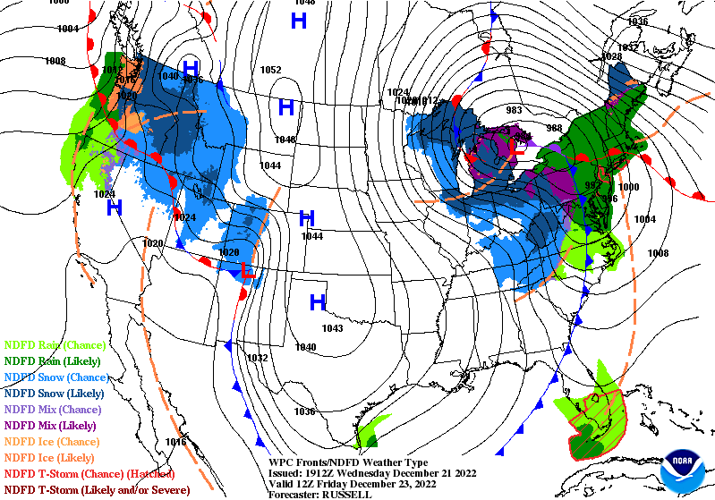 |
| The WPC’s forecast for the morning of Friday, December 23rd. |
This low will slingshot the cold toward the eastern states on Thursday and into Friday morning, bitter air riding in on southwesterly winds for many folks courtesy of the vigorous flow spiraling around the center of the storm.
Many folks across the east will see Friday’s high temperature happen either at midnight or during the early morning hours. This cold front will pack a punch all the way to the Atlantic, sending temperatures plummeting dozens of degrees in a matter of minutes.
The arrival of dangerous, life-threatening cold doesn’t even begin to touch this pre-Christmas storm’s other hazards.
Cold Temperatures
Extreme cold is nothing to scoff at. A cold snap like this can injure or kill hundreds of people through frostbite and hypothermia.
The same elderly, poor, unhoused, or chronically ill people who struggle through extreme summertime heat are vulnerable to frigid cold snaps like the one descending on the U.S. this week.
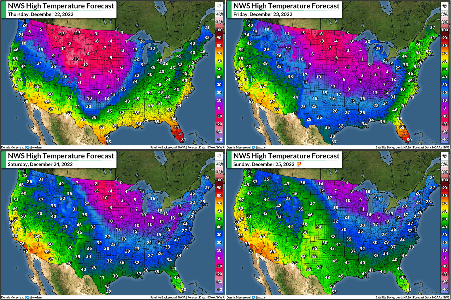
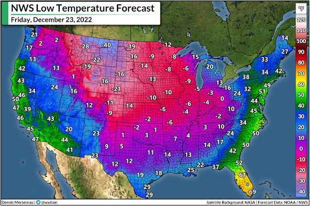
A vast swath of the country will face several straight days of subzero—and, for even more, subfreezing—temperatures heading into the Christmas weekend. That’s cold for anyone no matter how acclimated you are to winter weather.
Unprotected skin can begin to freeze in as little as 30 minutes when temperatures or wind chill values dip below zero. Frostbite is possible in a short while with readings in the double-digits below zero.
Frigid temperatures will easily reach the Gulf Coast over the next couple of days, with morning low temperatures into the lower 20s spreading over the Florida Panhandle. Temperatures below freezing will reach the Orlando metro area, and Miami is expecting a chilly low temperature of 47°F by Christmas morning.
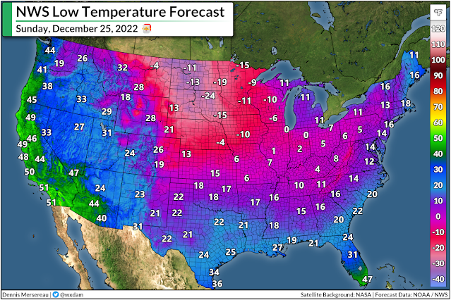
Wind chills will be even colder. Widespread wind chill warnings blanket the country from the Canadian to the Mexican borders.
No matter how much people fake-knowingly snicker at the idea, the wind chill isn’t made up.
Scientists developed the wind chill by studying how cold temperatures and wind affect the human body. Gusty winds on a frigid day chill your skin faster than your body would otherwise lose heat if it wasn’t windy out. A wind chill of -15°F means that the combination of cold air and gusty winds has the same effect on your body as an actual air temperature of -15°F.
Take this cold snap seriously. Cold air is bad enough, but it’ll be life-threatening for much of the country when you factor in the winds.
Flash Freeze
Most folks are going to see rain before the cold front roars overhead and temperatures plunge below freezing. Those wet roads and sidewalks won’t have a chance to dry off before the frigid air arrives, leading to a dangerous and widespread risk for a flash freeze.
We’re used to dealing with patches of black ice during the winter months, but a flash freeze is like if everything turned into black ice. A flash freeze on a major highway can cause significant pileup accidents.
If you’re travelling or heading home from work or school over the next couple of days, make sure you’re where you need to be once the cold temperatures hit—otherwise, you might get stuck wherever you are for a while.
Blizzard Conditions
Areas where precipitation follows the arrival cold temperatures will see heavy snow.
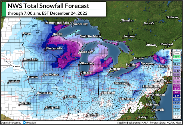
The heaviest snow will fall across the Great Lakes where the extreme temperature gradient between the relatively warm water and bitterly cold air will allow the lake-effect snow machine to crank at full capacity, especially off of Superior and Michigan.
Several inches of snow are possible across a widespread area from the central Plains toward the Northeast. It’s not going to be a blockbuster snowstorm away from the Lakes, but the very cold temperatures will make this a fine, powdery snow—perfect for blowing around.
Very strong winds will develop as the cold air floods in and the accompanying low-pressure system strengthens over the Great Lakes. Even if you’re only expecting a few inches of snow from this system, the powdery snow will easily blow around in the blustery winds, leading to whiteout or near-whiteout conditions for a very large area.
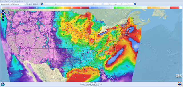 |
| NWS wind gust forecast for 10:00 a.m. EST on Friday, Dec. 23, in knots. (For reference, 30 knots is about 35 mph, and 40 knots is 46 mph.) |
It’s likely that driving will be nearly impossible at times throughout the central U.S. heading into this weekend. If you can avoid it, don’t go driving anywhere when it’s snowing. You really, really, really don’t want to get stuck on an impassable highway when temperatures are near or below zero.
It’s likely that the snow and winds will cause widespread delays and cancellations at the region’s major airports, including Chicago, Detroit, Pittsburgh, and Toronto. Bad weather affecting major hubs around a holiday is a recipe for hundreds (if not thousands) of delayed or cancelled flights.
Anticipate having to make alternate arrangements in a hurry, even if you’re not flying through the affected areas. All planes have to come from somewhere, and if your plane gets stuck up the line at a snowed-in hub, you’re not flying anywhere anytime soon.
Beware The Risk For Power Outages
The same high winds that will lead to dangerously cold wind chills and blizzard conditions could also lead to power outages. There aren’t really any good times for the power to go out, but the power going out during a life-threatening cold snap is exceptionally bad.
Make sure you’ve got enough to eat, flashlights to feel around at night, rechargeable battery packs for cell phones, and plenty of blankets just in case the high winds (or demand on the grid) cause power outages.