Skip to content
DAMWeather DAMWeather DAMWeather

The weather can get scary. Reporting on it doesn't have to be.

DAMWeather DAMWeather DAMWeather

The weather can get scary. Reporting on it doesn't have to be.

  • About Me
  • All Bylines
    • Books, Bylines, and Press
    • The Skies Above (Book)
    • Extreme Weather (Book)
    • The Weather Network
    • The Vane
    • Forbes
    • Capital Weather Gang
    • Mental Floss
  • Maps
    • Hurricane Maps
    • Hurricane Names
    • Monthly Tornadoes
    • Tornado Tracks
    • F5/EF-5 Tornadoes
    • SPC High Risk Days
  • GIS Resources
  • Contact Me
    • Bluesky
    • Facebook
    • Instagram
  • wxdam.com
  • About Me
  • All Bylines
    • Books, Bylines, and Press
    • The Skies Above (Book)
    • Extreme Weather (Book)
    • The Weather Network
    • The Vane
    • Forbes
    • Capital Weather Gang
    • Mental Floss
  • Maps
    • Hurricane Maps
    • Hurricane Names
    • Monthly Tornadoes
    • Tornado Tracks
    • F5/EF-5 Tornadoes
    • SPC High Risk Days
  • GIS Resources
  • Contact Me
    • Bluesky
    • Facebook
    • Instagram
  • wxdam.com
Close

Search

Dreaded Polar Vortex Drags Intense Freeze Over New England To End The Week

By Dennis Mersereau
February 2, 2023 2 Min Read

The much-maligned polar vortex will live up to its reputation over the next couple of days as some of the coldest temperatures on the planet dive south over New England on Friday and Saturday.
The polar vortex is a large-scale circulation that wraps around the Arctic Circle. It’s strongest in the winter months, when it acts like a moat keeping the winter’s coldest air confined to the far northern latitudes.
Every once and a while, this circulation will become unstable, creating troughs and upper-level lows that break off and head south. When this happens, it drags that bitterly cold air south right along with it.
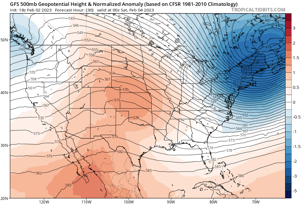
A model image showing the upper-level pattern responsible for New England’s deep freeze on Friday and Saturday. (Tropical Tidbits)
A fast-moving upper-level low—once part of the polar vortex circulation—swooping over eastern Canada is responsible for this impending blast of very cold air sagging into New England.
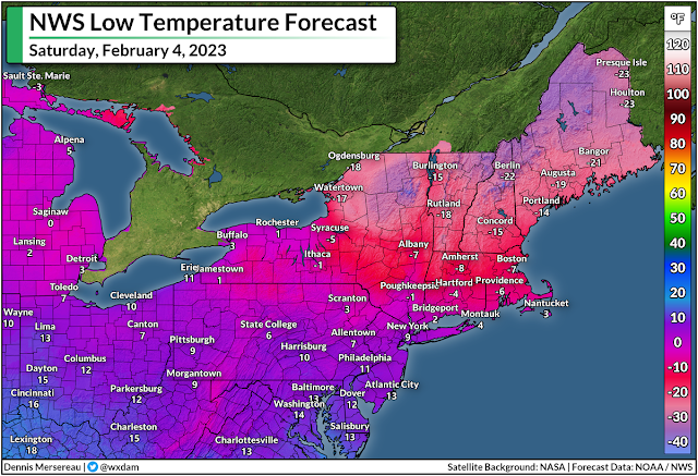
Temperatures will dive well below zero for many areas, with wind chill values in the double-digits below zero. The wind chill in Boston will dip below -30°F on Saturday morning, with wind chill values reaching the -40s in western Massachusetts. The National Weather Service predicts wind chill values all the way into the -60s for northern parts of New Hampshire and Maine.
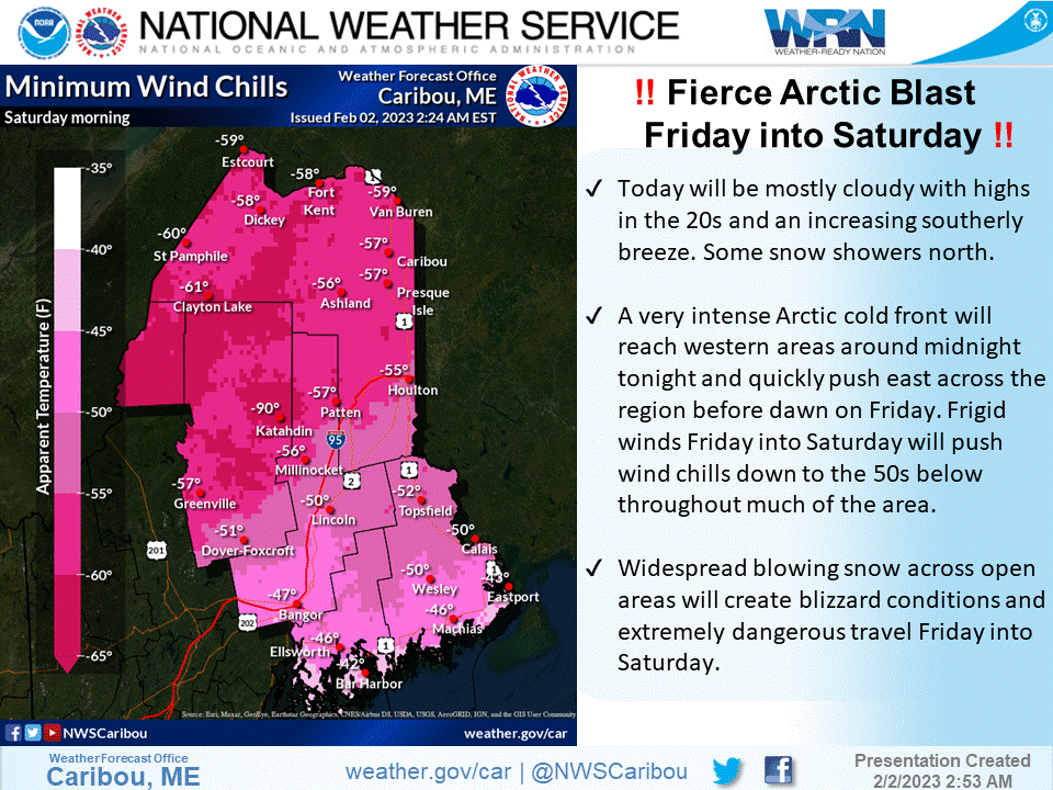
(NWS Caribou)
Don’t underestimate the risk posed by such low temperatures. This is dangerous cold, the kind that can cause serious injury in just a couple of minutes. Frostbite can develop on unprotected skin in as fast as two minutes with temperatures and wind chill values this cold.
It’s not going to last long, thankfully.
The pattern is pretty progressive, so the upper-level low responsible for the extreme cold will move along in a hurry. A ridge will build in behind it, allowing temperatures to rebound to above-normal territory in time for next week.

You can follow me on Facebook, Mastodon, Twitter, Instagram, or send me an email.

Please consider subscribing to my Patreon. Your support helps me write engaging, hype-free weather coverage—no fretting over ad revenue, no chasing viral clicks. Just the weather.


Author

Dennis Mersereau

I have 15+ of experience providing hype-free weather information for folks across the United States and around the world. In addition to DAMWeather, I also contribute to The Weather Network as a digital writer and weather specialist.

Follow Me
Other Articles
Previous

Enhanced Risk For Severe Storms Across Ohio Today, Because Of Course, It’s January 19th

Next

Record Snows Possible As Major Winter Storm Aims For Northern U.S.


Local ◈ UTC
Facebook | Bluesky
Instagram | Threads | Email
DAMWeather is now ad-free! Everyone benefits from engaging, hype-free weather coverage. Please consider supporting my efforts through Patreon:


Order The Skies Above today!

Bookshop.org || Barnes & Noble
Mountaineers Books || Amazon

My latest book, The Skies Above, is now available!

Did you know a puffy cloud can weigh millions of pounds? Or that every rainbow you see is unique to you?

Our atmosphere is full of spectacular sights that are always within your reach. Glistening layers of fog, gorgeous sunsets, and brilliant meteors flashing through the sky can light up even the calmest day.

The Skies Above, published by Mountaineers Books, is a celebration of what we overlook when we look up. I was thrilled to work with the editors and illustrators at Indelible Editions to share with you the quotidian beauty of our sky.

Order your copy now and learn about the wonders we take for granted every day.

I teamed up with the editors of Outdoor Life magazine to write The Extreme Weather Survival Manual, your guide to surviving and thriving in almost any weather condition. Whether you're an avid outdoorsperson or you enjoy watching the radar from the comfort of your home, you're sure to find helpful tips, advice, and new bits of knowledge in this fascinating book.

You can buy my book today through Amazon.
  • 2026 (34)
  • 2025 (49)
  • 2024 (59)
  • 2023 (43)
  • 2022 (57)
  • 2021 (71)
  • 2020 (83)
  • 2019 (88)
  • 2018 (92)
  • 2017 (1)
  • 2016 (4)
  • 2015 (10)

Copyright 2026 — DAMWeather. All rights reserved. Blogsy WordPress Theme