Record Snows Possible As Major Winter Storm Aims For Northern U.S.

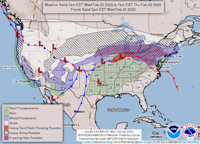
A high-end, highly impactful winter storm will sweep through much of the northern half of the country this week, producing deep snowfall and blizzard conditions along its path. The storm’s worst will focus on southern Minnesota, where more than a foot-and-a-half of wind-driven snow is possible.
The Setup
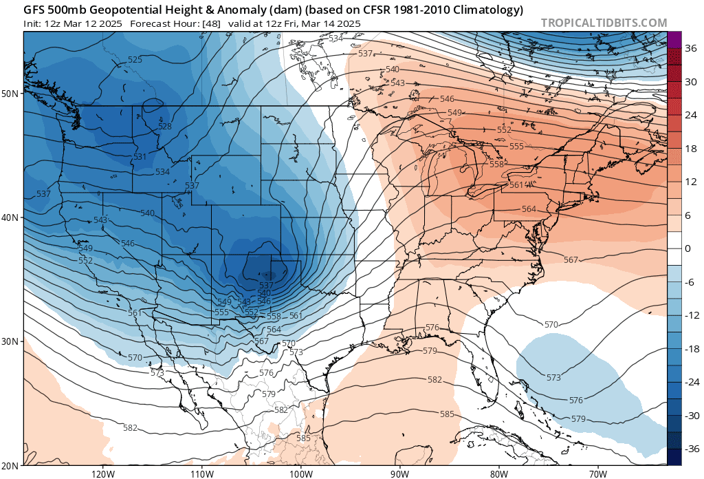
The upper-level pattern developing over the U.S. this week will resemble a case study from a meteorology textbook.
 |
| Source: Tropical Tidbits |
A vast trough over the western half of the country will give rise to the sprawling low-pressure system that’ll cause all the headaches for folks up north, while a formidable ridge over the east will give some areas a run at the warmest temperatures they’ve ever recorded in the month of February.
My town in north-central North Carolina could hit 83°F on Thursday afternoon—the second-warmest February day since records started here in 1901. Raleigh could rocket up to 87°F, shattering their monthly all-time temperature record by a couple of degrees.
When it comes to direct impacts, though, this spate of record heat is a relative footnote to the mammoth winter storm brewing beneath this impressive setup.
The seed that’ll grow into our disruptive storm is over British Columbia right now, bringing widespread gusty winds to the South Coast and more than a foot of snow to the mountain passes.
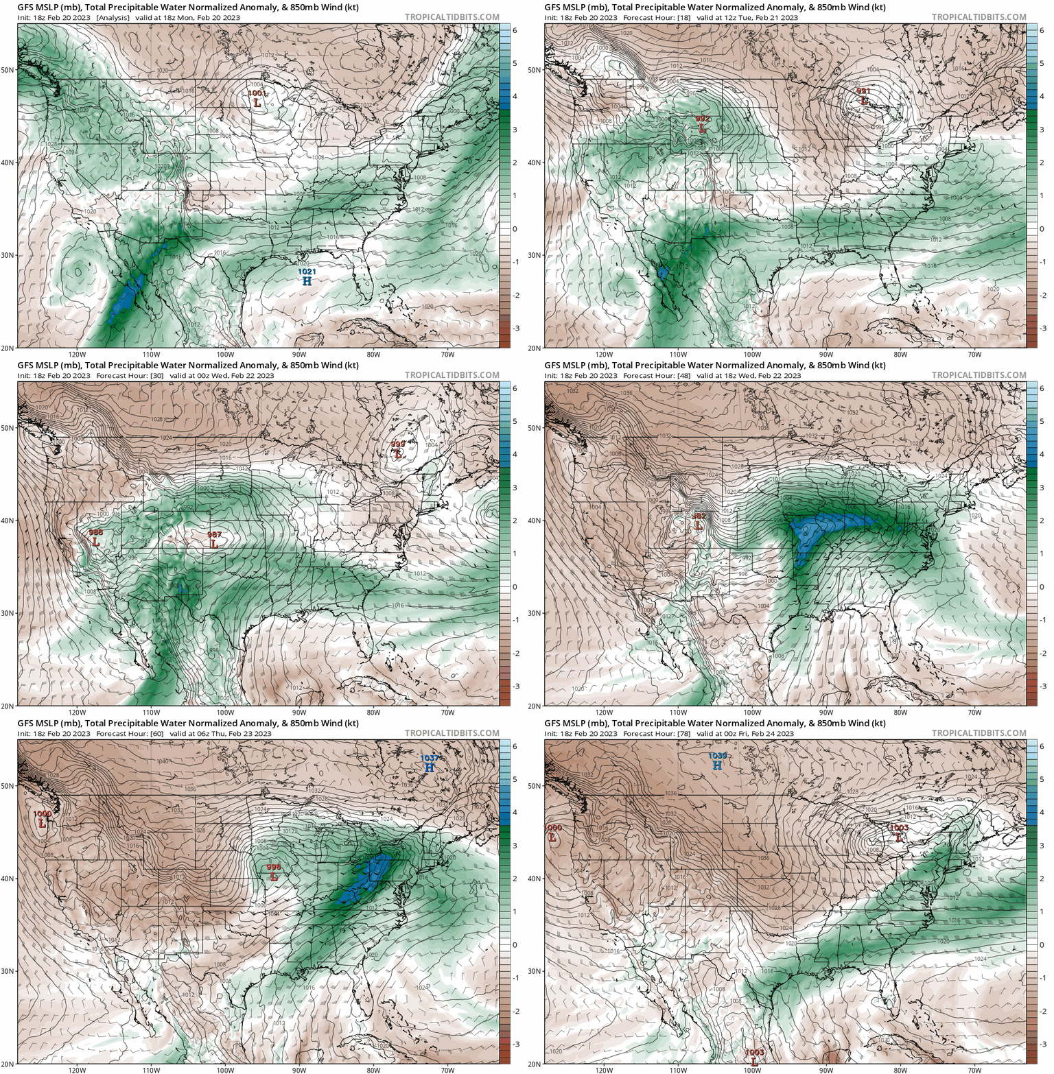
We’ll see this disturbance move southeast over the Rockies on Tuesday, laying the foundation for a very large winter storm to develop on the western Plains by Tuesday night.
 |
| Source: Tropical Tidbits |
A push of Pacific moisture with that initial disturbance will meet up with a surge of tropical moisture from the south (gawk at the animation above to see it in action).
This atmospheric doubletake will provide a vast reservoir for this developing storm to produce all the rain and snow it wants—and it sure seems like it’ll live up to its potential.
Heavy Snow
Snow is the biggest concern with this system. Here’s the Weather Prediction Center’s latest forecast showing the probability of 4 or more inches of snow through Thursday evening.
 |
| Source: Weather Prediction Center |
That’s a significant swath of land expecting a healthy blanket of snow!
Here’s the same forecast showing the probability of more than 12 inches of snow:
 |
| Source: Weather Prediction Center |
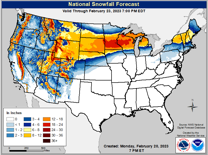
Forecasters are increasingly confident that a huge chunk of the Upper Midwest stands to see more than a foot of snow through the end of the week, with parts of Minnesota and Wisconsin—including the Twin Cities—possibly seeing 18+ inches of snow from this system.
A foot-and-a-half of snow is common with a nor’easter on the East Coast, but it’s a solid, high-end storm for the Upper Midwest. If that scenario played out, it would be at least the 8th largest snowstorm on record at Minneapolis-St. Paul.
Snowstorms in the middle of the country typically don’t have this much moisture to work with—it’s usually their winds that cause issues more than the immobilizing amounts of snow.
 |
| Source: National Weather Service |
Blizzard Conditions
This storm certainly won’t be short on winds.
Widespread gusts of 40-50 mph will create a lengthy period of blizzard condition from the Rockies through the Upper Midwest.
The combination of heavy snow and fierce winds will reduce visibility to zero for many hours during the height of the storm. People caught on highways could get stranded without aid for a life-threatening period of time. Air travel will be a headache days after the storm, with the ripple effects of delays and cancellations at major hubs affecting flights across the country.
Bitter Cold Soon To Follow
 |
| Source: National Weather Service |
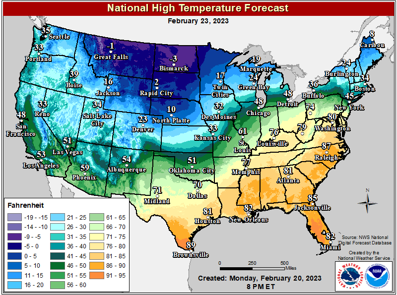
Adding insult to injury, a burst of extremely cold temperatures will immediately follow behind the storm as it exits to the east. Subzero daytime highs will be the norm in Montana and North Dakota. The National Weather Service predicts a low in Minneapolis of -7°F after the snow stops on Thursday night. Highs will struggle to reach the teens there on Friday.
Very cold temperatures across the northern Plains and Upper Midwest will combine with lingering breezy conditions to make for dangerous wind chills across the region. Frostbite and hypothermia will be a concern for anyone spending a while outside after the storm trying to clear the snow.
[Top Image: Weather Prediction Center]

You can follow me on Facebook, Mastodon, Twitter, Instagram, or send me an email.
Please consider subscribing to my Patreon. Your support helps me write engaging, hype-free weather coverage—no fretting over ad revenue, no chasing viral clicks. Just the weather.