Idalia on track to hit Florida as a major hurricane Wednesday


Idalia could grow into a major hurricane as it aims toward western Florida by the middle of the week. The system “should keep strengthening up to landfall,” according to the National Hurricane Center (NHC), which is a scary and all-too-familiar prospect for storms hitting the Gulf Coast in recent years.
Widespread damaging winds, flooding rains, and a risk for tornadoes will extend well inland from the point of landfall, likely bringing hazardous conditions to a wide swath of the southeastern U.S. through the end of the week.
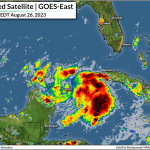
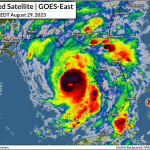
Tropical Storm Idalia is taking full advantage of the environment around the system this weekend as it rapidly gets its act together off the tip of the Yucatan Peninsula. The system, which has remained near-stationary for the past couple of days, used the opportunity to improve its structure and gather strength over the region’s steamy waters.
The storm had maximum winds of 65 mph by 8:00 a.m. on Monday, and it’s likely going to grow into a hurricane during the day as it slowly makes its way north toward the western tip of Cuba.
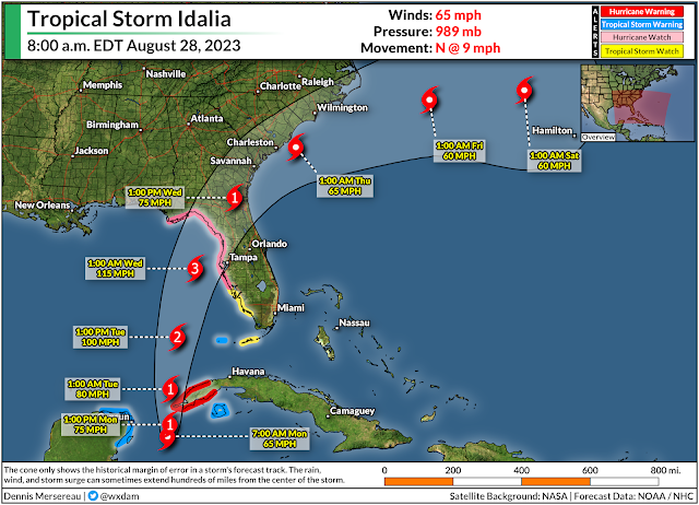
Lower wind shear and ample warm waters will give the system free reign to strengthen as much as possible over the next couple of days as it heads toward the western Florida coast. The NHC calls for the storm to reach major hurricane status before landfall during the early morning hours on Wednesday.
At this point, the only potential impediment to its strengthening would be the storm’s internal structure. If it struggles a bit, or undergoes an eyewall replacement cycle at some point, it will hamper (if not just briefly) the storm’s strengthening trend.
Communities along the coast are at greatest risk for life-threatening conditions as Idalia strengthens and heads toward its inevitable landfall early Wednesday morning.
This is a high-stakes forecast, as small shifts in the storm’s position or track could have huge implications for folks along the coast. It wouldn’t take much of an eastward jog to bring the storm closer to the Tampa Bay area, which would push stronger winds, heavier rain, and a greater surge into the coast.
 |
| Source: NHC |
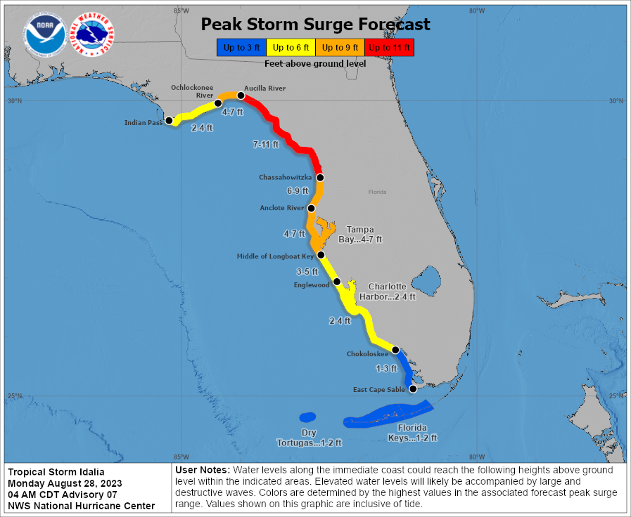
The NHC expect a maximum potential storm surge of 7-11 feet along the Big Bend between the Aucilla River and Chassahowitzka, which could happen if the storm’s landfall coincides with high tide.
Farther south, we could see a surge of 4-7 feet push into Tampa Bay, which could lead to extensive flooding in this heavily populated metro area. A surge of 2-4 feet is possible farther south in Charlotte Harbor, with tropical storm conditions bringing a 1-3 foot storm surge into the Keys.
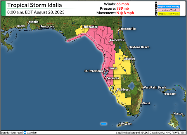
The effects of a landfalling tropical cyclone don’t stop at the coast. Idalia will maintain its strength for a good while after landfall, bringing hurricane conditions to much of northern Florida, and tropical storm conditions to a large swath of southern Georgia and coastal counties in the Carolinas.
Hurricane watches and tropical storm watches were in effect early Monday morning for much of inland Florida along Idalia’s path, and these alerts will likely upgrade to warnings later this morning or afternoon.
Widespread tree damage and power outages are likely as the storm pushes inland, with some communities near the point of landfall and immediately inland potentially going without power for a week or longer.
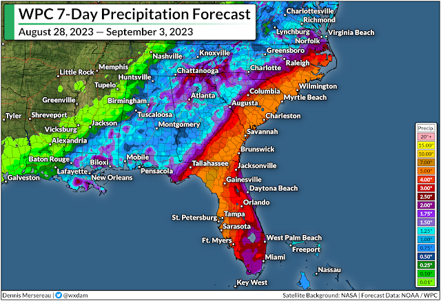
Flooding rains will pose a significant hazard to much of northern Florida and southern portions of Georgia and the Carolinas through the end of the week. A moderate risk for flash flooding will follow the storm’s path inland, with Jacksonville, Savannah, Charleston, and Wilmington potentially seeing more than 5 inches of rain from Idalia by next weekend.
Again, the precise track of the storm will significantly affect where the heaviest rains fall. A jog east or west would push the greatest rainfall totals right along with it. There’s also likely going to be a sharp cutoff in rain on the northern edge of the storm.
Flooding from heavy rain is the leading cause of death in any landfalling tropical cyclone. Most flood deaths occur in vehicles. It’s a serious hazard that often gets overlooked in favor of the storm’s raging winds.
Never try to drive across a flooded roadway. It’s impossible to tell how deep the water is until you’re already in it, and sometimes the road is washed out beneath the water. It only takes a small amount of water to lift a vehicle and carry it away, risking the lives of those in the vehicle and those who have to conduct rescue or recovery.
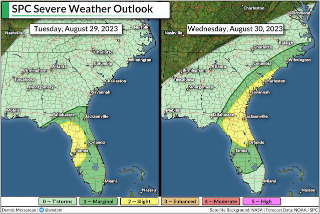
There’s also a risk for tornadoes through the week as the storm makes landfall. Tornadoes are most likely along and to the right of the storm’s path, which will place the greatest tornado risk across much of the Florida Peninsula and coastal sections of Georgia and the Carolinas.
Tropical tornadoes happen quickly, sometimes so fast that they leave little or no advanced warning before they form. Take a moment to check your phone and ensure that emergency alerts are activated for tornado warnings. Lots of folks disable them entirely after one too many ill-timed AMBER Alerts. These push alerts for tornado warnings are proven lifesavers. You don’t want to miss an alert that could save you and your family.
The NHC will issue updates on the storm every three hours this week, with full forecasts issued every six hours at 5:00 and 11:00 a.m/p.m. Local National Weather Service offices will handle flash flood warnings and tornado warnings as the storm pushes inland.

Follow me on Facebook | Bluesky |
Threads | Instagram | Twitter
Threads | Instagram | Twitter
Get in touch! Send me an email.
Please consider subscribing to my Patreon. Your support helps me write engaging, hype-free weather coverage—no fretting over ad revenue, no chasing viral clicks. Just the weather.