Destructive winds, widespread flooding likely far inland as Hurricane Idalia makes landfall

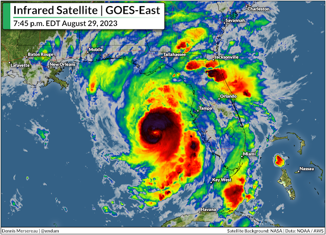
Hurricane Idalia is picking up speed toward northern Florida on Tuesday night as the storm continues to grow in strength and size over the sultry waters of the eastern Gulf of Mexico.
This is a deadly serious threat for coastal communities in the path of the storm, many of which have not witnessed a storm this powerful in the region’s living memory.
While the coastline faces the life-threatening prospect of 10+ feet of storm surge and the full force of a major hurricane, this storm’s impacts will extend far inland. This is not just a coastal threat, and these far-reaching storms often catch folks off-guard when they’re hundreds of miles from the point of landfall. That’s what I’ll focus on here.
The storm’s destructive winds, widespread flooding, and tornadoes will extend far inland from the point of landfall, exposing a large swath of northern Florida and coastal sections of Georgia and the Carolinas to significant and potentially long-lasting impacts from this powerful storm.

Hurricane Idalia spent Tuesday taking advantage of a favorable environment to rapidly intensify as it heads toward the western coast of Florida. The storm’s maximum sustained winds crossed 100 mph on Tuesday afternoon, with the National Hurricane Center (NHC) expecting the Idalia to make landfall early Wednesday morning as a major hurricane.
The storm is likely to intensify all the way up to landfall, which could mean its maximum winds could climb to 120 mph or higher by the time the eyewall crosses the marshy coastline of Florida’s Big Bend, likely near the community of Cedar Key.
Conditions will go downhill in a hurry as Tuesday night settles in, and the hurricane’s high winds and drenching rain will quickly push ashore through the overnight hours as the storm makes landfall early Wednesday morning.
High winds and power outages
Idalia’s ferocious winds, increasing speed, and the marshy terrain in the hurricane’s path will allow the storm to maintain its intensity as it pushes inland through the day Wednesday.
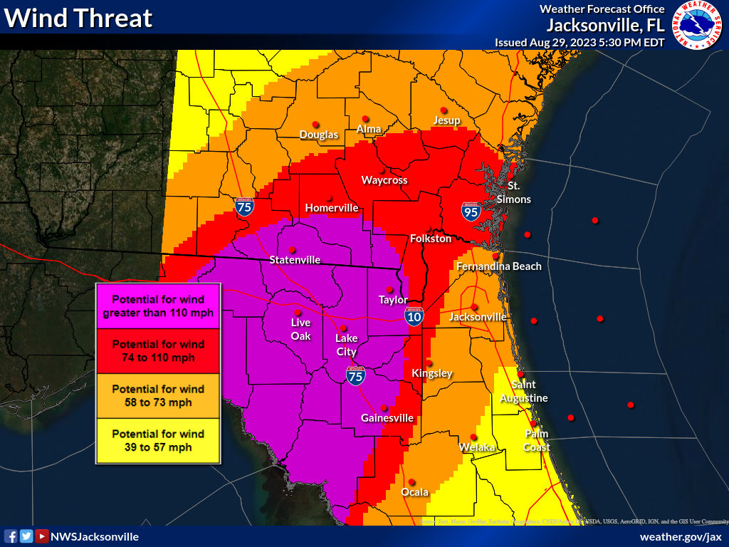
Destructive winds are likely across much of northern Florida and southern Georgia, where hurricane warnings are in effect from Tampa to Tallahassee and north past Valdosta. Tropical storm warnings extend even farther inland, covering most of northern Florida—including Orlando and Jacksonville—as well as southeastern Georgia and all of coastal South Carolina.
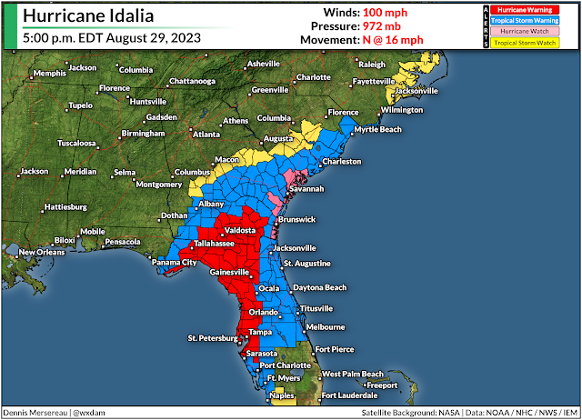
Winds of 120+ mph will push into Florida’s Apalachee Bay, which has seen exactly zero major hurricanes in recorded history. NWS Tallahassee is stressing that this is an unprecedented event for the region, and it’s likely going to be the strongest hurricane to affect Tallahassee proper in living memory.
Given the marshy terrain and swift forward motion, it’ll take a while for Idalia to lose steam. Sustained winds of 75+ mph are likely well into southern Georgia during the day Wednesday. Sustained winds of 60 mph will likely follow the storm all the way to Charleston, South Carolina, by the overnight hours Wednesday into Thursday.
Such a widespread wind event will lead to a significant blowdown of the dense forests that cover this portion of the southeastern United States. Expect many impassable roads for days after the storm, especially smaller and less-travelled roads.
 |
| Source: NWS |
Hundreds of thousands of homes and businesses will remain without power for many days after the storm, with the worst-hit areas likely going without electricity for several weeks as crews quite literally rebuild the power grid.
These widespread power outages will be a major disruption for folks who live in the region.
Communities that experience prolonged blackouts will see their perishable foods spoil and few options to buy groceries or other necessary supplies. Cooking will be extremely difficult without natural gas, propane, or outdoor grills. Tap water may require boiling—or stop running altogether—if water lines are damaged or municipal providers lose power themselves.
In addition to the basic supplies like water, food, and hygiene products, flashlights and batteries are an essential resource. The flashlight feature on your phone is the easiest way to kill your battery, which is a scary prospect in a lengthy power outage.
Widespread flash flooding
The number one cause of death in any landfalling tropical system is flash flooding from heavy rains, and most of those flood-related deaths occur in vehicles.
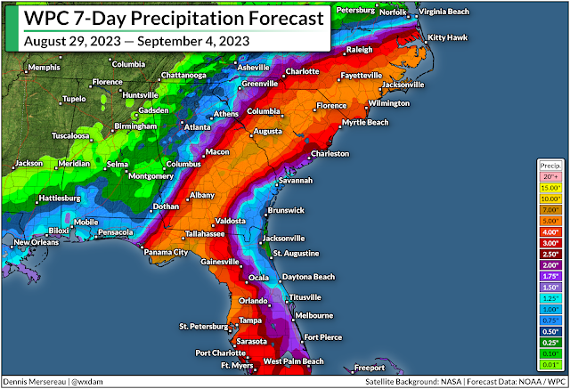
Forecasters expect 5-7+ inches of rain to fall along Idalia’s path as it cuts from Florida to South Carolina. This glut of drenching rain will likely cause flash flooding throughout the area, especially in flood-prone areas. There are always roads that flood in storms like this, and there are always people who try to ford the high water anyway.
It’s impossible to tell how deep the water is until you’re in it and it’s too late. It only takes a small amount of standing water to lift a vehicle and carry it away, threatening the live of those in the vehicle and those who have to go rescue them or recover their bodies.
Tornadoes are likely through Thursday
Tornadoes are a hazard with any landfalling tropical system. Supercell thunderstorms are common in the outer bands of a storm as high instability and strong wind shear allow these tiny storms to spin like tops.
Tropical tornadoes happen quickly—sometimes touching down and lifting in between radar scans, only lasting a couple of minutes with very little tornado warning lead time.
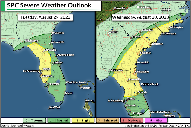
These tornadoes are most likely along and to the right of the storm’s path, which places the greatest risk for tornadoes across the Florida Peninsula through Tuesday night into early Wednesday, and across coastal region of Georgia and South Carolina during the day Wednesday into early Thursday.
Take a look at your phone and make sure that wireless emergency alerts are turned on for tornado warnings. These free push alerts are proven lifesavers in tornadoes, and the screeching tone is likely to wake even the soundest sleeper.