Tropical Storm Lee expected to grow into an intense hurricane this weekend

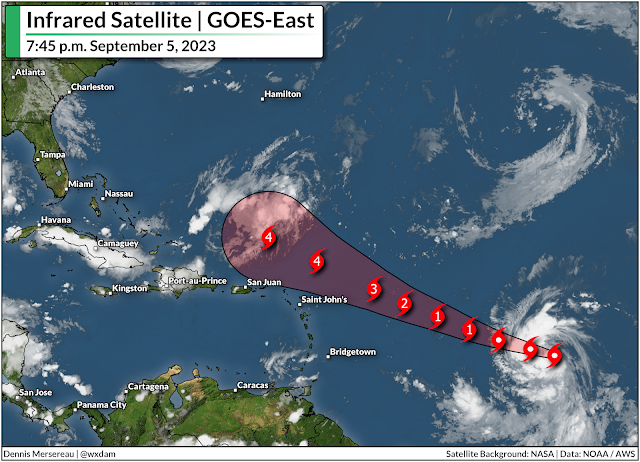
The National Hurricane Center (NHC) came out swinging on Tuesday when they issued their first advisory on what is now Tropical Storm Lee. The storm is moving into an extremely favorable environment for strengthening, and forecasters are confident that Lee will grow into a powerful hurricane in the days ahead.
Lee has been a formidable system since its early days as a disturbance rolling off western Africa. It’s had ‘that look’ to it for several days now—persistent thunderstorms and an overall swirl that pretty much made its development a foregone conclusion.
The system developed enough Tuesday to earn its status as tropical depression, quickly upgrading to a low-grade tropical storm with maximum sustained winds of 45 mph at 5:00 p.m. on Tuesday.
Conditions over the tropical Atlantic are very favorable for rapid development, especially for a system as healthy and well put-together as Lee. Forecasters expect Lee to steadily strengthen over the next five days, growing into a hurricane by Wednesday night and then into a major hurricane by the end of the week.
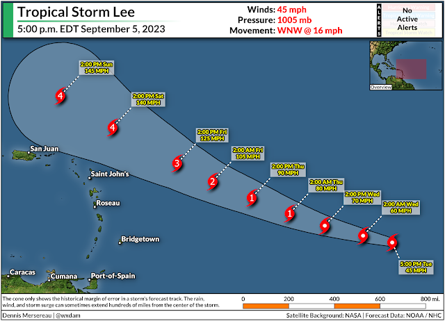
All indications point toward Lee becoming a very powerful hurricane by this weekend. The NHC’s current forecast puts a strong category four hurricane north of the Lesser Antilles by Saturday. At this point, the only limit to Lee’s strength may be how well it’s able to organize its own internal structure.
It’s very uncomfortable to see a powerful hurricane heading west across the Atlantic Ocean. It’s also been a very long time since we’ve had a long-track Cape Verde-type hurricane like this.
Almost all of our big storms over the past couple of years developed relatively close to land. As best as I can tell, this is our first storm since 2019’s Hurricane Dorian to have a 7-10+ day rollout from deep in the tropical Atlantic toward the western half of the ocean basin.
The extended, anxiety-filled watch-and-wait routine is tough in the social media era, especially with so many new hype-filled pages angling to fill the vacuum.
It is still too soon to say whether or not Lee will have any impacts on the United States late next week or beyond. Models are hinting at a potential recurve next week, but there are still too many variables and moving parts to make a call with any certainty. A slight difference in the placement of ridges and troughs will affect how these features tug and push on the storm, for instance.
Uncomfortable as it is, we really will have to watch and wait as the storm develops to see how it will interact with the environment and what its path could look like. We’ll start to get a clearer idea toward the end of the week and this weekend.
Even if Lee winds up heading out to sea, it’s best to prepare for a hurricane now so you’re ready for whatever might come your way the rest of the season. The climatological peak of hurricane season is next week, and the tropics usually stay active through October and even into November.
Check your emergency supplies to make sure you’ve got enough non-perishable food, water, hygiene products, and batteries to last several days without power. Invest in a few battery packs to recharge your devices, and make sure you’ve got flashlights so you’re not draining your cell phone battery using it to feel around in the dark. If you live in a flood-prone area, have evacuation plans ready long before you’d ever need them. Plan out alternate routes to work/school/stores in case of flooded roads.
We don’t have to wait until a storm threatens to run through all these prep routines. It’s good to have them in place so you have one less worry if anything ever does loom on the horizon.