Classic fall storm could bring the southeast strong tornadoes, beneficial rains

A classic fall storm revving up across the central United States this week could bring severe thunderstorms to the southeast—along with beneficial rains for areas falling into a pretty serious drought over the past couple of months.
Some of the severe thunderstorms on Monday could grow quite strong across Louisiana and Mississippi, bringing a risk for a couple of strong, long-lived tornadoes.
Fall severe weather season ramps up
‘Tis the season for severe weather in the south, and this looks to be our first real “second season” severe weather outbreak of the year. November and December see a noticeable uptick in severe weather across the southeast as powerful low-pressure systems develop over the Plains and roll north toward the Great Lakes.
Warm, humid air streaming north out of the Gulf of Mexico provides the instability, while the storm and its fronts provide the lift and wind shear needed to push the resulting thunderstorms beyond severe limits.
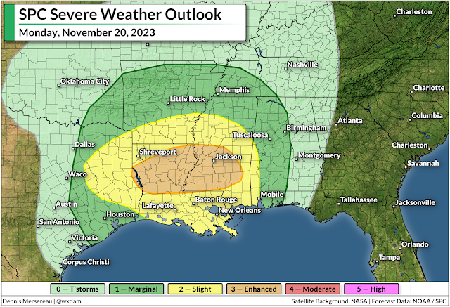
The Storm Prediction Center issued an enhanced risk for severe weather across northern Louisiana and much of southern and central Mississippi during the day Monday. Thunderstorms will develop during the afternoon and sweep across the region from west to east.
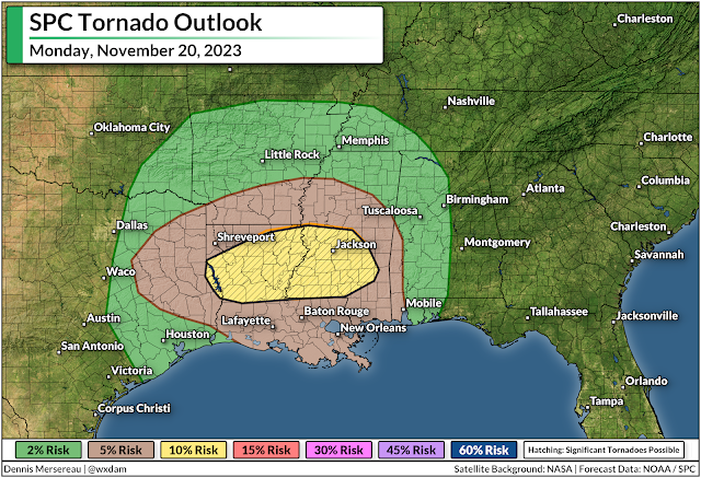
All modes of severe weather are possible, but the headline (as always) is the risk for tornadoes. Forecasters see enough instability and wind shear that a couple of those tornadoes could be strong or long-lived in and around the enhanced risk area.
Aside from the tornado risk, any of the thunderstorms that bubble over the region on Monday could produce strong wind gusts of 60+ mph, as well as a risk for large hail.
Make sure you have a way to get warnings
It’s been a long while since we’ve had to contend with a risk for severe weather. Make sure emergency alerts are activated on your phone so you’ll know the moment a tornado warning is issued for your location. Make a mental note of all the safe places at home, work, school, and various places you run errands in case dangerous weather strikes during the day.
Much of the severe weather threat on Monday and early Tuesday will unfold after sunset. Severe weather is especially dangerous after dark as people tune out and wind down for the evening. It’s more important this time of year than ever to stay weather-aware, keeping up with storms nearby and having a way to receive warnings as soon as they’re issued.
Remember—never rely on tornado sirens as your first line of defense. These sirens are outdoor warning systems not meant to be heard indoors, and they’re prone to failure in bad weather.
A taste of beneficial rains on the way
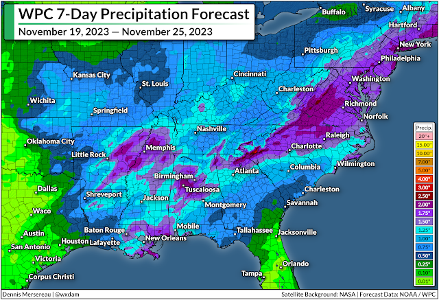
Even with the threat for severe weather, the widespread rain we’ll see over the next couple of days is welcome news for just about everyone in the region.
Much of the south has slipped into severe or extreme drought over the past couple of months as dry patterns prevailed and tropical systems largely avoided making landfall on the northern Gulf Coast.
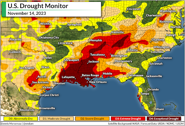
Some areas have seen their annual rainfall totals fall more than a foot behind where they should be by the middle of November. It’ll take a lot of rain to ameliorate the growing effects of this extended drought, but even an inch or two of rain is a welcome step in the right direction.
Another low-pressure system could develop in the western Gulf of Mexico late in the week around Thanksgiving, which could bring another quick hit of rain to areas that desperately need the water. Beyond that, we could be in for another dry pattern that’ll likely last into the opening days of December.