Reality check: What we do and don’t know about the looming cold snap


A surge of cold air looming over the eastern half of the United States has social media buzzing with the possibility of frigid temperatures and wintry precipitation.
We’re really going to endure a spell of colder-than-normal temperatures through at least the first half of January. There’s also a real chance for widespread snow and ice during this period. Here’s a look at how much of the chatter is just that—chatter—and how much is legit.
The Setup
The upper-level pattern for the past couple of weeks has featured a ridge over the eastern half of North America with a trough over the western half of the continent.
Ridges foster sinking air, which warms up and dries out as it descends toward the ground. Troughs allow for colder temperatures and more unsettled conditions as they force air to rise.
We’re going to see this pattern flip around heading into the first week of January, with broad troughing developing over the eastern halves of the U.S. and Canada. This will send eastern temperatures dipping below normal as we experience a phenomenon known as cross-polar flow—which is exactly what the name implies.
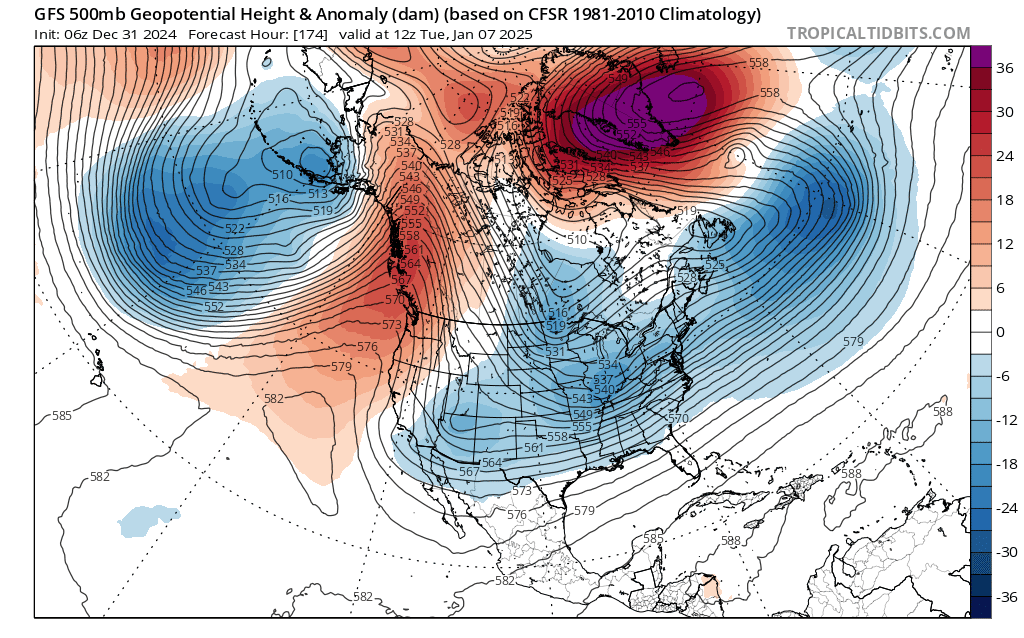 |
| A model image of the upper atmosphere on January 7, 2025. (Tropical Tidbits) |
In the model image above, you can see a broad trough over the east while a sharp ridge builds over the West Coast. Most of the lines are parallel from far Northern Canada all the way to the southeastern U.S., opening the floodgates for Arctic air to pour southward by the second week of January.
As a result, the Climate Prediction Center (CPC) is extremely confident that we’ll have below-normal temperatures through the first half of January. The agency gives 80-90+ percent odds of below-normal readings between January 7th and January 13th.
Reality Check
What does this mean for you? Here’s a look at average high and low temperatures for any given January 10th for a few eastern cities:

If we get temperatures coming in 10 degrees below normal, we’re looking at days hovering around the freezing mark in New York and D.C., while it’s a brisk winter’s day for places like Memphis and Atlanta.
There are hints in the models that we’re going to get temperatures much colder than 10 degrees below seasonal. It’s still too soon to place exact numbers on daytime highs and nighttime lows, but it’s possible that we could have the opportunity for single-digit or even subzero readings to dip pretty far south for a day or two.
And then there’s the elephant in the room: snow. Any chance for snow is a big deal south of the Mason-Dixon line, especially in places like North Carolina where it’s been two years since our last shovelable snowfall.
This type of pattern is favorable for one or more low-pressure systems to develop in the southern states and move toward the East Coast. Snow and ice are a decent possibility with cold air already in place.
We’re still more than a week from this pattern settling into place. It’s far too early to say who could see snow, sleet, or freezing rain, let alone detailing any accumulations.
The heart of winter is on its way. Prepare for an extended period of chilly conditions with opportunities for wintry precipitation thrown in the mix. Keep up with the latest forecasts and make sure you’re prepared to stay warm—and possibly even shovel some snow.
Follow me on Facebook | Bluesky | Instagram
Get in touch! Send me an email.
Please consider subscribing to my Patreon. Your support helps me write engaging, hype-free weather coverage—no fretting over ad revenue, no chasing viral clicks. Just the weather.