Major winter storm set to snarl travel from Kansas City to Philly


Plenty of folks from Kansas to New Jersey are looking at their first winter storm of the season, which is slated to bring a significant swath of wintry precipitation from Kansas City to Philadelphia. Severe thunderstorms are possible on the southern side of the system.
The Setup
An upper-level trough rolling over the Rockies will spark the development of a low-pressure system over the Texas Panhandle on Saturday night. The low, drawing on moisture from the south, will develop in a hurry and bring a wide swath of wintry precipitation from the Midwest to the Mid-Atlantic.
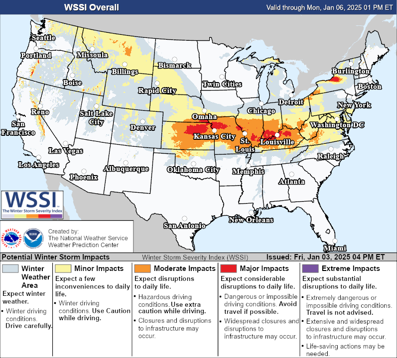
This is going to be a formidable and memorable winter storm for some areas. Portions of the Midwest could see more than a foot of snow by the end of this system, while communities just south could see enough freezing rain to cause widespread power outages and tree damage.
We often talk about the track of a winter storm because a few miles to the north or the south could make a dramatic difference in whether communities get hammered by snow, coated in ice, or soaked in a cold rain.
This is a high-stakes forecast because so many major cities are right on the delicate line between snow, ice, and rain. The track of this storm will be key—if it tracks 20 miles north or south of where meteorologists currently expect, it would drag the swaths of heavy snow and freezing rain along with it. That’s a bad prospect when so many big cities are perilously close to the lines between snow, ice, and rain.
Timing
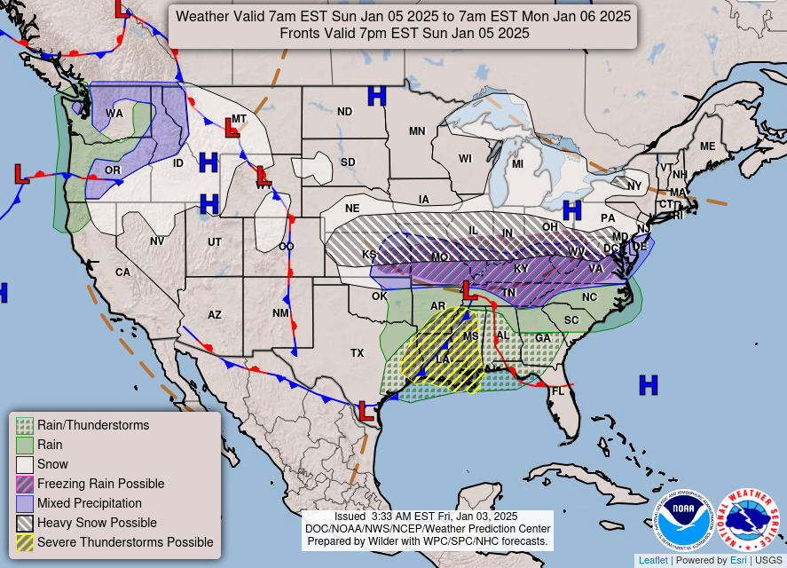
The storm will begin developing over the central Plains by Saturday night. We’ll see widespread snow and ice envelop Kansas and Missouri through the overnight hours, continuing into Sunday night around St. Louis.
Snow and ice will spread across Illinois and Indiana through Sunday morning, continuing throughout the day and into the nighttime hours across the region. Expect significant icing across southern Illinois, southern Indiana, and much of Kentucky through Sunday and into Sunday night.
Precipitation will start crossing the Appalachians by Sunday evening, with snow beginning across D.C., Baltimore, and Philadelphia overnight into Monday. This is likely going to be an all-day event Monday.
On the southern side of the system, severe thunderstorms are likely to get going on Sunday afternoon and continue through the overnight hours into early Monday morning. Nocturnal severe thunderstorms are especially dangerous as people tune out the weather and head to bed. Make sure you have a way to receive warnings the moment they’re issued if you’re in the area.
Accumulations

As of Friday afternoon, the National Weather Service calls for a significant swath of heavy snow from central Kansas to southern New Jersey.
Kansas City, St. Louis, Indianapolis, Washington, and Baltimore all stand to see 6 or more inches of snow from this system. Some communities in northern Kansas and the northern half of Missouri could see more than 12 inches of snow through this weekend.
This much snow will be more than enough to make travel nearly impossible during the height of the storm. School, government, and business closures are almost certain on Monday and Tuesday, especially across the Mid-Atlantic.
Severe Thunderstorm Risk

Severe thunderstorms are a common risk during winter storms tracking across the middle of the country. Unstable air on the southern end of the low-pressure system will fuel thunderstorms across the Deep South.
The main threat will be damaging straight-line winds as storms form along a cold front pushing from Texas to Alabama. Embedded tornadoes within that squall line can’t be ruled out.
Follow me on Facebook | Bluesky | Instagram
Get in touch! Send me an email.
Please consider subscribing to my Patreon. Your support helps me write engaging, hype-free weather coverage—no fretting over ad revenue, no chasing viral clicks. Just the weather.