High-risk tornado outbreak expected in the Deep South on Saturday


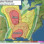
A rare ‘high risk‘ for severe weather—a level five out of five—is in effect for a swath of the Deep South on Saturday as a dangerous thunderstorm setup sweeps across the region.
The Storm Prediction Center (SPC) only issues one or two high risk areas every year. This means that forecasters are confident in the likelihood of a tornado outbreak across the affected areas.
The Setup and Risk
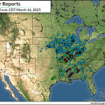
A powerful low-pressure system rolling across the center of the country unleashed deadly severe thunderstorms Friday and through the overnight hours. Multiple tornadoes and widespread wind damage were reported from Texas to Minnesota.
That setup is pushing east to start the weekend, with a second and even more intense round of severe thunderstorms expected through the day Saturday.

Strong instability and ample wind shear should give rise to widespread severe thunderstorms by Saturday afternoon. Conditions are favorable for these storms to quickly turn into supercells capable of producing intense, long-track tornadoes, as well as destructive wind gusts and hail the size of golf balls or larger.
While all modes of severe weather are possible, the greatest concern remains the tornado threat. If today’s risk lives up to its potential, this could be a high-end outbreak with multiple intense tornadoes in and around the moderate and high risk areas.
Potential Hiccups
Tornado outbreaks are relatively rare for a reason. These devastating events require all the ingredients aligning just right to spawn significant severe weather. It appears that all those ingredients are in place in the right sequence today.
But sometimes things don’t work out as expected. What are the potential modes of failure today?
Forecasters expect multiple dangerous supercells to roll across the moderate and high risk areas, bringing with them a threat for significant tornadoes. However, it’s not out of the realm of possibility that we could see thunderstorms quickly align into one or more squall lines, in which case the predominant threat would transition to widespread damaging winds with the potential for embedded tornadoes.
Existing cloud cover across the region could rob the atmosphere of some of the instability it needs to allow thunderstorms to flourish across areas under the highest risk for severe weather. This appears less likely given the storms already bubbling up at the time of this post’s publication.
That said—all the warning lights are blinking red. This is a serious threat and folks in the region should pay close attention to the weather and ensure they’ve got a way to stay safe if dangerous conditions threaten.
Severe Weather Safety
Make a plan in advance where to go in the event a tornado warning is issued for your location. Mentally map out the safest part of your home, as well as where you’d duck for cover in commonly visited places like school, work, grocery stores, and while you’re in your vehicle.
Ensure you have a way to receive severe weather warnings the moment they’re issued. Please remember that tornado sirens are not reliable and they’re not meant to be heard indoors.
Check your phone now and ensure that emergency alerts are enabled for tornado warnings. These free push alerts are a lifesaving defense against dangerous thunderstorms. The system triangulates your location based on your cell signal to determine if you’re in a tornado warning. It works, and it’s saved countless lives over the past decade.
Always have a backup when it comes to receiving severe weather alerts. NOAA Weather Radios are like smoke detectors for the weather. You can program these devices to sound a loud alarm the moment your county is included in a watch or warning—even when the power’s out and they’re running on batteries.
The NWS Is At Risk
The forecasts referenced in this article were issued by the National Weather Service, a critical federal agency that’s likely responsible for directly saving more lives than just about any other office in the government. The National Weather Service costs $3 per year per taxpayer.
Free and instant lifesaving warnings, Doppler radar data, satellite imagery, computer models, and realtime observations would likely vanish if this agency were gutted. Please contact your representatives to urge lawmakers to save NOAA and the National Weather Service from irreparable damage.
Follow me on Facebook | Bluesky | Instagram
Get in touch! Send me an email.
Please consider subscribing to my Patreon. Your support helps me write engaging, hype-free weather coverage—no fretting over ad revenue, no chasing viral clicks. Just the weather.