Season’s first hurricane potentially brewing in the Gulf of Mexico

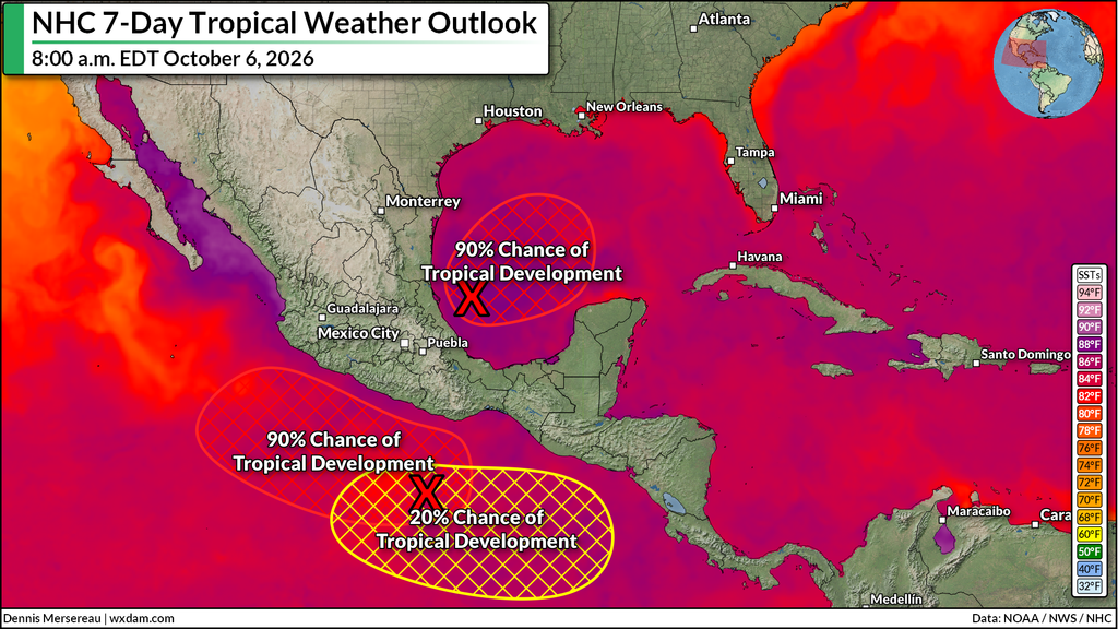
A tropical disturbance in the southern Gulf of Mexico has a high chance of developing into Tropical Storm Isaias by the middle of the week.
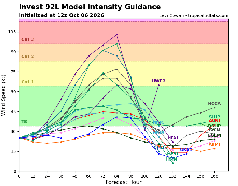
The system will enter a favorable environment for intensification, and an increasing number of models show that it may become the season’s first hurricane before making landfall late this week or this weekend.
Future Isaias is in a complicated environment with several opposing forces at play. The precise setup will determine the system’s future intensity, path, and impacts.
We’ve long warned that it only takes one disruptive storm to make big waves even during an exceptionally quiet hurricane season. This has the potential to be that storm.
A complex environment over the Gulf
Let’s start with what’s working in the system’s favor.
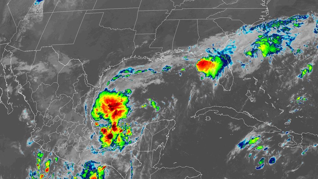
1) The tropical disturbance already exists and its thunderstorm activity is relatively healthy. The thunderstorms need to coalesce around a closed center of low pressure for this to qualify as a tropical depression or tropical storm.
2) Sea surface temperatures across the Gulf are historically warm for this time of year.
3) There’s a window of opportunity for the storm to intensify without too much interference from dry air or wind shear.
4) Given these factors, an increasing number of computer models are on board with the system developing into the season’s first hurricane.
Now, here’s what’s working against the storm’s future development.
1) Wind shear will increase across the Gulf as we get closer to the weekend. Strong winds disrupt the thunderstorms that power tropical cyclones, forcing them to weaken and lose organization.
2) Those very warm sea surface temperatures are quite literally at the surface. The Gulf of Mexico is unusually cool just a bit deeper. A slow-moving storm will quickly churn up those cooler waters and limit its ability to intensify.
3) There are two tropical disturbances in the eastern Pacific not far from the Gulf system. Depending on the development and movement of these features, they may pump some disruptive wind shear toward the Gulf of Mexico.
Potential track and impacts
Tuesday morning’s model runs are fairly consistent in showing the storm tracking east before turning toward the northern Gulf Coast, potentially affecting cities from Lafayette, Louisiana, east toward Tallahassee, Florida. They’ll have a better handle on the track once the center of the storm actually forms. (Until then, models are trying to track a moving target that doesn’t exist yet.)
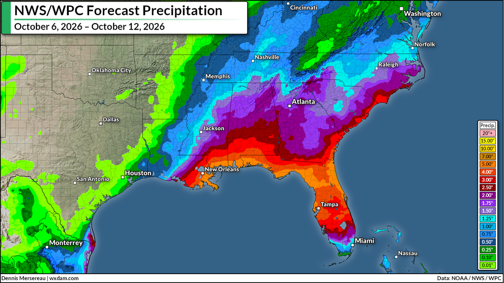
Regardless of track or intensity, the greatest threat will be flash flooding from widespread heavy rainfall. Forecasters with NOAA’s Weather Prediction Center expect an additional 3-5+ inches of rain to fall on top of what the northern Gulf Coast has already seen since this weekend. These totals will almost certainly change with the storm’s organization and track.
Flash flooding is far and away the greatest danger in any landfalling tropical cyclone. Never try to drive across a flooded roadway. It’s impossible to tell how deep the water is until it’s too late, and it only takes half a foot of moving water to lift a vehicle from the roadway.
Strong winds could also lead tree and home damage. Depending on the storm’s intensity, long-lasting power outages are possible around where the center makes landfall.
We’ll also have to watch the threat for tornadoes on the eastern side of the system, which would likely be southern sections of Alabama, Georgia, and the Florida Panhandle. Tropical tornadoes can happen quickly with reduced warning lead time.
Follow me on: Facebook | Bluesky | Instagram
Please consider subscribing to my Patreon. Your support helps me write engaging, hype-free weather coverage–no fretting over ad revenue, no chasing viral clicks. Just the weather.