
states that could result in some flooding issues and power outages. Aside from potential
issues caused by heavy rain and gusty winds, much of the hullabaloo surrounding
this storm stems from the term “bomb cyclone,” a hypetastic phrase that appears
in just about every news article about the storm. Here’s a quick look at how
the storm will strengthen so quickly.
Gusty Winds and Heavy Rain
of tonight’s storm. Winds are gusting as high as 50 MPH in spots as the storm moves through the area; the combination of wet
soil and full foliage will stress trees to their tipping point, potentially
leading to power outages, home damage, and blocked roads. Don’t forget to stick
your phone on your charger before going to bed tonight, and be mindful of large
limbs or trees looming over your home.
could lead to flooding issues in low-lying areas. Roads that are normally fine
during heavy rain at other times of the year could see standing water or
outright flooding due to fallen leaves clogging up drains and sewers.
Bomb Cyclone
We can’t escape it. It’s like “polar vortex” and “wedge tornado.” It’s just
there and we’ll have it forever and it’ll be used to get clicks until the
internet dissolves in the fiery inferno of the Sun’s…wait, what was I talking about?
minimum central pressure drops 24 mb in 24 hours. The resulting storm—a “bomb
cyclone,” if you will—is usually pretty impressive in both its effects and its
appearance on satellite imagery
 |
| Record low air pressure records for the month of October. | Source: NOAA/WPC |
had a minimum central pressure of 998 mb as it passed over the Delmarva
Peninsula at 2:00 PM on Wednesday. Its pressure had dropped to 988 mb six hours
later as it approached New York City. Most weather models have the system’s
minimum pressure falling below 975 mb as the storm moves into interior New
England during the day on Thursday. A pressure that low would set some all-time
minimum pressure records at some weather stations in New England; air pressure records for the month of October are shown above.
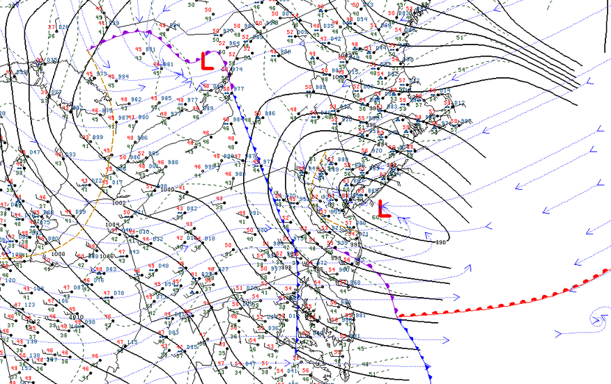
Divergence describes winds fanning out in the upper levels of the atmosphere. Winds tend to spread apart as they leave the base of a trough or as they enter and exit stronger parts of the jet stream, known as jet streaks. Air has to rush upward to fill the void left behind by the diverging winds, leaving less air—a center of low pressure—at the surface.
 |
| An analysis of the jet stream at 8:00 PM on Wednesday. | Image: Tropical Tidbits, with my annotations |
A strong trough, combined with two different jet streaks, are all working together to lift massive amounts of air from the surface. If multiple sources of divergence align with each other like we’re seeing right now, air has to rush upward from the surface really fast to compensate for the void left by the winds spreading out. This leads to the rapid strengthening of a low-pressure system at the surface. The storm will begin to weaken once it starts to lose that lift from above. In this case, the storm will slowly lose steam as it meanders toward Atlantic Canada on Friday.
Please consider subscribing to my Patreon. Your support helps me write engaging, hype-free weather coverage—no fretting over ad revenue, no chasing viral clicks. Just the weather.