Hurricane Zeta Will Bring Strong Wind, Heavy Rain To Northern Gulf Coast On Wednesday


Tropical Storm Zeta will restrengthen into a hurricane before making landfall in eastern Louisiana on Wednesday. The storm made its first landfall as a hurricane near Cancun on Monday. Forecasters expect Zeta to restrengthen as it accelerates toward the northern Gulf Coast over the next day. Strong winds, a dangerous storm surge, flash flooding from heavy rain, and tornadoes are possible as the storm races inland.
The tropical storm had a tremendous pinwheel appearance on satellite imagery this evening. The system’s outer bands and upper-level outflow covered most of the Gulf of Mexico. It’s one of the most stunning satellite images we’ve gotten from a storm in a while.

A closer look at the core of the system shows a tropical storm that’s on the cusp of strengthening. Favorable conditions over the southern Gulf of Mexico, combined with sufficiently warm sea surface temperatures, should allow the storm to regain hurricane strength as it picks up speed and moves toward eastern Louisiana.
There’s a chance that the storm could ramp up rather quickly tonight, especially if that eyewall can wrap around and close itself off. Given the expected increase in its forward speed, it’ll be difficult for the storm to shed much of the strength it manages to build up as it nears landfall.

Eastern Louisiana has been in the cone of uncertainty quite a few times this year. Laura and Delta went west. Marco weakened. Sally went east. But those were different storms in different situations. Zeta looks like it’s on a direct approach to eastern Louisiana, with hurricane conditions likely in and around New Orleans at the height of the storm. Don’t let your guard down because all the other storms missed you. This one probably won’t miss.
Once the storm makes landfall, Zeta will get swept up by a cold front as the system races over the southeast. The system could actually start to restrengthen a bit as it moves inland toward the Mid-Atlantic as a result of extratropical transition. The system will start gathering some of its energy from the jet stream on Thursday, which could lead to an increased threat for damaging winds for folks well inland from the point of landfall.
Wind
The greatest potential for wind damage will occur at and around the point of landfall. Hurricane force winds can easily blow down trees and power lines. Folks who experience the strongest winds should prepare for power outages that last at least a couple of days.
Even though the storm will weaken to a tropical storm as it moves inland, don’t think that you’re in the clear when it comes to strong winds. Tropical storm watches extend into northern Georgia in anticipation of a thump of strong winds as Zeta and its remnants race through the area. Somewhat similar to what we saw with Isaias a couple of months ago, the storm will begin feeding some of its energy from the jet stream like an extratropical cyclone. This will allow Zeta to produce strong winds over a wide area even when it’s hundreds of miles inland.
If you’re anywhere near the forecast path of the storm—whether you’re on the Gulf or in central North Carolina—take stock of your supplies and make sure you’ve got enough food, water, batteries, and other items necessary to make it through a power outage.
Also, try to avoid rooms where large trees or tree limbs loom overhead outside. Trees falling into structures are responsible for lots of injuries during storms like this.
Storm Surge
 |
| Source: NHC |
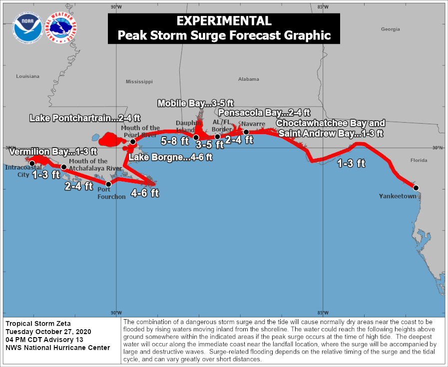
A life-threatening storm surge could occur along the coast when Zeta makes landfall. The latest forecast from the National Hurricane Center calls for a potential maximum storm surge of 5 to 8 feet above ground level near and to the right of the point of landfall. Based on the current forecast, this maximum surge is possible along the coast in Southern Mississippi and Dauphin Island, Alabama. A storm surge could extend as far east as Florida’s Big Bend.
Folks who live at the coast don’t really need to be told this, but storm surge is nothing to mess around with. The water can rise quickly and cut off means of escape before folks who stayed behind realize that they should’ve evacuated. If you’re told to evacuate, it’s wise to heed the word. Once the storm is raging, you’re on your own until it’s over.
Rain

Heavy rain will track along Zeta’s path inland. The Weather Prediction Center expects up to 5 inches of rain in southern Mississippi. The threat for flooding rains will follow the path of the storm all the way through the Mid-Atlantic, where several inches of rain are possible by the end of the week.
This much rain in such a short period of time will lead to flash flooding issues in vulnerable areas.
Flash flooding is the leading cause of fatalities during landfalling tropical cyclones in the United States. It only takes a few inches of moving water to lift up a vehicle and carry it downstream. It’s impossible to judge the depth of the water over a roadway until it’s too late, and sometimes the road isn’t even there anymore underneath the floodwaters.
If you have to go out during the storm, make sure you know several ways to get around so you an avoid flooded areas.
It’s worth noting that not all of the rainfall on this map is from Zeta. Much of the rain west of the Mississippi River is from the storm system producing a major ice storm in Oklahoma and Texas, while the bulk of the rain over the Mid-Atlantic and Northeast is from Zeta merging with that storm system by the end of the week.
Tornadoes

As always, there’s a threat for tornadoes as the hurricane makes landfall. The greatest threat lies to the right of the storm’s forward motion, which puts the greatest tornado risk in parts of Mississippi, Alabama, and Florida on Wednesday evening.
Tropical tornadoes occur quickly with reduced lead time. Even though these tornadoes tend to be weaker than we’d see in a springtime outbreak, even the smallest, weakest tornado is a life-threatening hazard if you’re in its path. Make sure you’ve got a way to receive tornado warnings the moment they’re issued by activating the Wireless Emergency Alerts feature on your smartphone.
[Satellite Images: NOAA]
You can follow me on Twitter or send me an email.
Please consider subscribing to my Patreon. Your support helps me write engaging, hype-free weather coverage—no fretting over ad revenue, no chasing viral clicks. Just the weather.