Mid-Atlantic Preparing For Decent Snowstorm, Sudden Freeze A Risk Monday Night

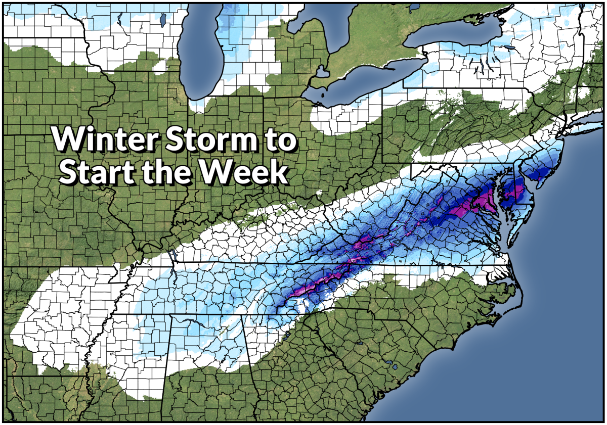
The season’s first snowstorm is on its way for the Mid-Atlantic, and it could be the region’s first formidable snowfall in a while for many areas. Some lucky folks could wind up with double-digit snowfall totals by the end of Monday. This is one of those rare events where snow seemed unlikely until just recently, so it could come as a surprise to folks who tuned out the weather this weekend.
A strong low-pressure system will rapidly develop and strengthen over the southeast late Sunday into early Monday. There’s no shortage of moisture for the low to work with, so it’s going to be a prolific rain- and snow-maker for much of the southeast and Mid-Atlantic.
Around these parts, cold air usually has to be here first before we can talk about accumulating snow. This is one of those setups where the Arctic air flooding in from the central U.S. will chase the low into the region. It appears likely that this upcoming storm will break the rule and cold air will arrive fast enough for hefty snowfall totals to fall from the Appalachians to the Atlantic.
Winter storm warnings stretch from the Blue Ridge Mountains to the New Jersey shore ahead of the snow. Winter weather advisories are more expansive, with everyone from Memphis to Philadelphia getting in on at least a little bit of winter weather.
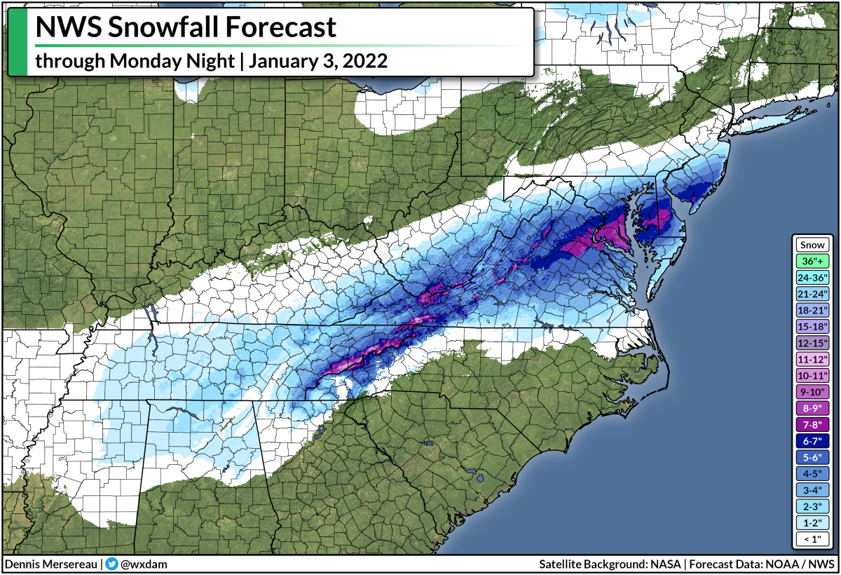
The map above looks a little janky, I know. This is a compilation of all the forecasts from local NWS offices as of 4:30 p.m. EST. Some of the offices update faster than others, and the snowfall amounts along office boundary borders don’t always match up.
Still, you can get the general idea that the heaviest snow will fall over the southern Appalachians and through central Virginia, stretching toward the Delmarva and southern New Jersey. It’s worth noting that the axis of heavy snow depends on the track of the storm, and it may wind up inching closer to the D.C. area.
Some areas could wind up notching double-digit snowfall totals before the storm ends on Monday afternoon. If it comes to fruition, this is going to be a decent storm for a region that hasn’t seen many of them in recent years.
The sticky, wet snow—combined with gusty winds—could lead to power outages in some areas, so make sure you’ve got some flashlights, a fully charged cell phone, and some ready-to-eat food on hand in case the lights go out.
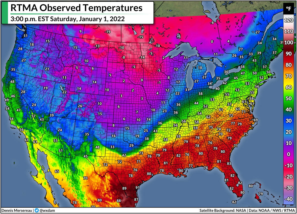
The snow will have trouble sticking to roads and sidewalks, especially in areas only expecting minor accumulations. The ground is warm. It’s been unusually warm back east for the past couple of weeks. Highs on Saturday climbed into the 60s and 70s across the Mid-Atlantic and Carolinas.
Heavy snow rates will overcome warm ground temperatures and lead to snowy and slushy roads in areas expecting more than a couple of inches of snow.
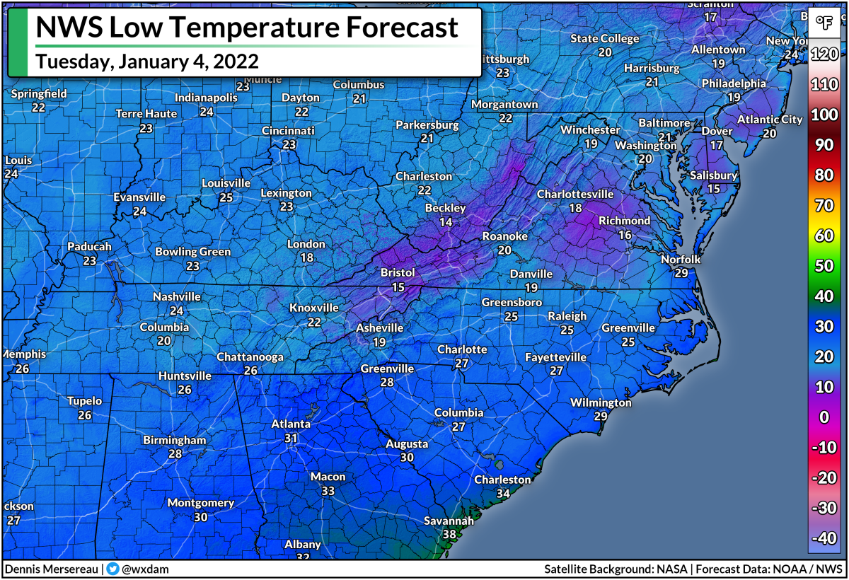
We could see a sudden freeze behind the system as temperatures plunge Monday night into Tuesday. Low temperatures on Tuesday will push into the teens across Virginia and fall into the 20s from northern Mississippi into the Carolinas.
Refreezing and black ice will become a huge problem come Tuesday morning, even in areas where snow didn’t stick to paved surfaces. Any standing water left on the roads Monday night will freeze as the Arctic air settles over the area, making for dangerous travel conditions heading into Tuesday.
On the warmer side of the storm, several inches of heavy rain in a short period of time could lead to flooding issues. Flood watches are in effect for much of central and eastern North Carolina ahead of the rainfall Sunday night into Monday.
So…where did this storm come from?
Snowstorms don’t often take us by surprise anymore. Models and forecasting methods are pretty good today, and it’s more likely for a snowstorm to underperform than to kinda sneak up on us. Remember the storm of January 2000? That was a true surprise. What appeared to be nothing turned into a major winter storm that dropped a foot of snow over parts of the I-95 corridor. That was a complete whiff.
This one is sneaking up on us, sure, but we’re still a day out from the biggest impacts. Folks have plenty of time to get ready and alter their plans with this storm…as long as they’re paying attention and hear the winter storm alerts, that is. We’re used to having days and days of advance notice, but a seemingly quick storm like this is a reminder that we should always pay attention to the forecast in case something dramatically changes.
Personally…I’m looking forward to the opportunity for even a little bit of snow. Not only has it been warm for the past couple of weeks, but many areas expecting snow through Monday haven’t really seen much snow at all.
I live in Reidsville, N.C., which is just north of Greensboro. Our last significant snowfall was on December 9-10, 2018, when we got 16.5″ of snow in the third-largest snowstorm ever recorded here.
Take a look at what we’ve seen since then:
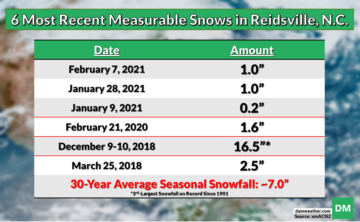
Reidsville picks up about 7″ of snow in a typical season. We saw 2.2″ last winter, 1.6″ the winter before that, and a blockbuster 16.5″ of snow on December 9-10, 2018, which clocked in as our third-biggest snowstorm since records began in 1901. We got one big storm more than two years ago and we’ve had hardly anything since. Just pitiful. Hopefully we get a little more with this storm.
You can follow me on Twitter or send me an email.
Please consider subscribing to my Patreon. Your support helps me write engaging, hype-free weather coverage—no fretting over ad revenue, no chasing viral clicks. Just the weather.