Severe weather risk builds as another powerful spring storm develops

The risk for severe thunderstorms will build heading into this weekend as yet another significant low-pressure system roars to life across the center of the country.
Widespread severe thunderstorms are likely on Friday and Saturday, an event the Storm Prediction Center described on Wednesday as a potential “outbreak.”
The Setup
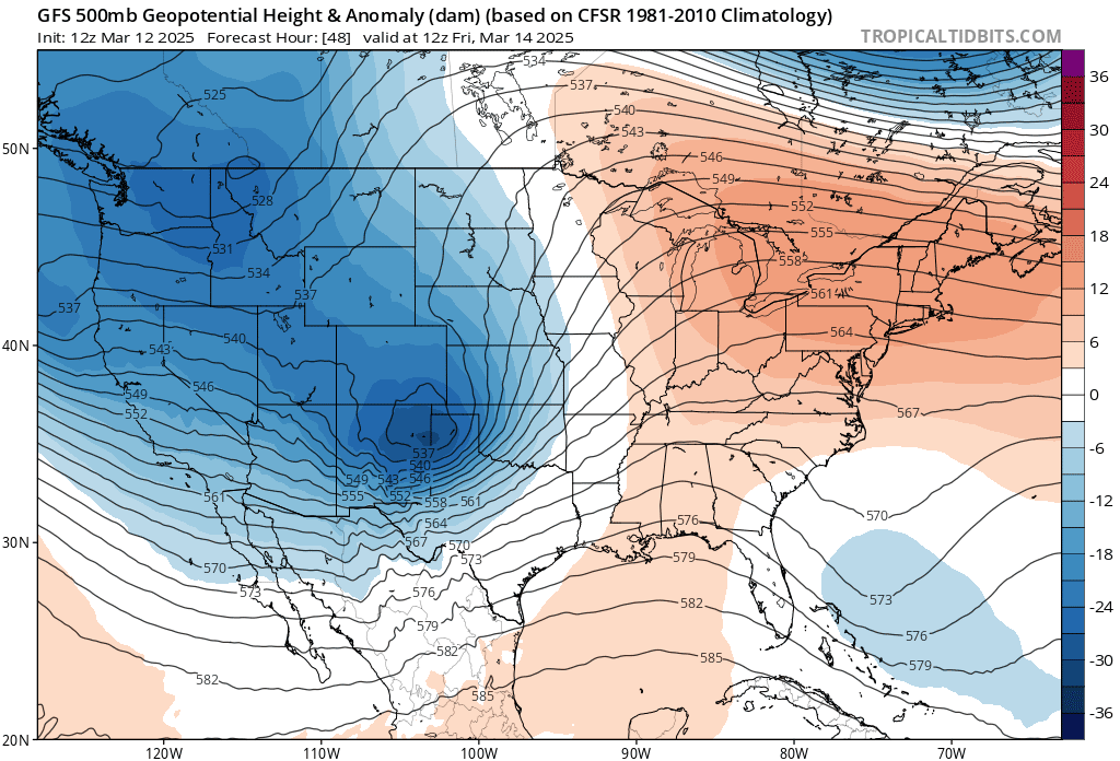 |
| A model snapshot of the trough that’ll give rise to our powerful low-pressure system on Friday (Tropical Tidbits) |
A powerful trough swinging over the West Coast will cross the Rockies to end the week. The lift from this trough, combined with a powerful jet stream over the southern U.S., will give rise to a rapidly developing low-pressure system over eastern Colorado early on Friday.
This Colorado low will deepen in a hurry as it traverses the Plains toward the Upper Midwest. Much like the storm we saw last week, this system’s rapid intensification could threaten some monthly air pressure records from Nebraska to Minnesota.
High Winds
A rapidly deepening low-pressure system is a recipe for widespread powerful winds. Expect wind advisories and high wind warnings to eventually blanket much of the central and southern U.S. as this storm builds over the region. Wind gusts in excess of 40 mph, with much higher gusts, will be possible Friday and Saturday.
The combination of high winds and dry air wrapping around the backside of the system will create a multi-day wildfire risk across large chunks of New Mexico, Texas, and Oklahoma. Any wildfires that spark through the weekend could quickly grow out of control and threaten nearby communities.
Severe Thunderstorms—FRIDAY

Warm, unstable air surging inland on southerly winds will create ample instability throughout the middle of the country on Friday. Intense wind shear associated with the developing storm will give the storms the kick they need to quickly turn severe.
Forecasters expect severe thunderstorms to spread from west to east through the day. All modes of severe weather—damaging winds, large hail, and tornadoes—will be possible on Friday.
The Storm Prediction Center (SPC) has issued an enhanced risk, a level three out of five, for much of the Mississippi Valley from northern Mississippi into north-central Illinois, including the cities of Memphis and St. Louis.
“Not only will extreme wind field favor damaging winds, but profiles will also favor supercells capable of fast-moving tornadoes, whether a broken line or in QLCS fashion along surging outflows,” the SPC said in its forecast on Wednesday. A QLCS—quasi-linear convective system—is a squall line.
Severe Thunderstorms—SATURDAY

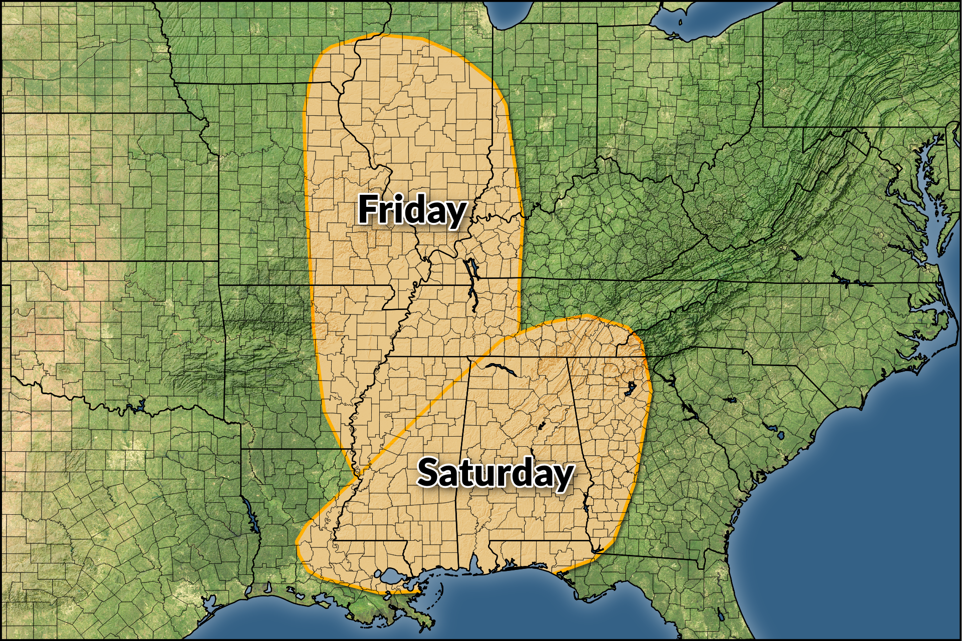
The greatest risk for severe thunderstorms will develop on Saturday as the focus of the threat moves into the Deep South. All the dynamics are in place for a potential severe weather outbreak across the region.
The SPC doesn’t issue categorical outlooks four days in advance, so we have a more generic risk map (shown above) to highlight the threat for severe weather on Saturday. An orange 30% risk is roughly the same as a level three enhanced risk for severe weather.
All modes of severe weather will be possible on Saturday. The concern will grow if Friday’s leftover thunderstorm activity doesn’t stabilize the atmosphere, which would allow for more favorable dynamics for severe weather on Saturday.
“If this scenario unfolds, a concerning severe weather setup supporting all-hazard severe could unfold across portions of LA/MS/AL through the day and into evening, and eventually spreading east into GA overnight,” the SPC said on Wednesday.
Severe Thunderstorms—SUNDAY

No matter what happens on Saturday, it’s likely that we’ll see thunderstorms continue east overnight and approach the eastern seaboard heading into the day Sunday.
The SPC highlighted a slight risk for severe weather from northern Florida through northeastern Pennsylvania ahead of these storms. It’s likely that damaging winds would be the predominant threat from these storms, but dynamics may be favorable for a tornado or two.
Severe Weather Safety
Make a plan in advance where to go in the event a tornado warning is issued for your location. Mentally map out the safest part of your home, as well as where you’d duck for cover in commonly visited places like school, work, grocery stores, and while you’re in your vehicle.
Ensure you have a way to receive severe weather warnings the moment they’re issued. Please remember that tornado sirens are not reliable and they’re not meant to be heard indoors.
Check your phone now and ensure that emergency alerts are enabled for tornado warnings. These free push alerts are a lifesaving defense against dangerous thunderstorms. The system triangulates your location based on your cell signal to determine if you’re in a tornado warning. It works, and it’s saved countless lives over the past decade.
Always have a backup when it comes to receiving severe weather alerts. NOAA Weather Radios are like smoke detectors for the weather. You can program these devices to sound a loud alarm the moment your county is included in a watch or warning—even when the power’s out and they’re running on batteries.
The NWS Is At Risk
The forecasts referenced in this article were issued by the National Weather Service, a critical federal agency that’s likely responsible for directly saving more lives than just about any other office in the government. The National Weather Service costs $3 per year per taxpayer.
Free and instant lifesaving warnings, Doppler radar data, satellite imagery, computer models, and realtime observations would likely vanish if this agency were gutted. Please contact your representatives to urge lawmakers to save NOAA and the National Weather Service from irreparable damage.
Follow me on Facebook | Bluesky | Instagram
Get in touch! Send me an email.
Please consider subscribing to my Patreon. Your support helps me write engaging, hype-free weather coverage—no fretting over ad revenue, no chasing viral clicks. Just the weather.